How does multi-GRIB routing work?
- Francis
- mars 7, 2026
NavimetriX allows you to select multiple atmospheric models for routing calculations. The principle is to combine multiple resolutions on a given route. This is particularly useful for offshore voyages.
How it works
Multi-GRIB routing works as follows: when several wind GRIB files are added, the application automatically selects the best GRIB for each point and each moment of the calculation, based on three priority criteria:
- The finest resolution first (a GRIB at 0.025° will take priority over a GRIB at 0.25°).
- At equal resolution, the most recent run is preferred.
- At equal resolution and run, the most recently downloaded file is used.
We therefore do not “mix” models, which would not make sense, but “chain” them according to the distance to be covered and the coverage of each model. The multi-GRIB option only works for wind models.
An example:
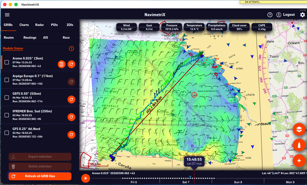
Let’s consider a crossing of the Bay of Biscay, departing from Lorient and arriving in La Coruña. You can use an Arome 0.025° model for the departure, and an ARPEGE Europe 0.1° or ICON Europe 0.0625° model to take over if Arome expires before your arrival. This allows you to calculate a single route instead of two successive routes.
Implementation
After downloading the GRIB files needed to cover (largely) your sailing area and activating your route:

Tap/click on the quick action icon and select “Calculate a route.”
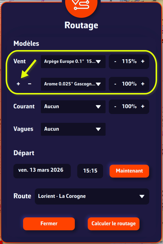
- Select an “Atmospheric” wind model.
- Tap the small + button to select a second wind model. The first one should be the one with the longest lifespan.
- If necessary, select a wave model from “Sea State”.
- If necessary, select a current model.
- Choose your departure date (note: not too far in the future).
- Check that the route is displayed correctly.
- Press the “Calculate Route” button.
What is it used for?
The principle is to obtain the best possible resolution at the start of a voyage in order to refine the routing, and only reduce the resolution over the long term.
If we consider a transatlantic crossing, typical use is as follows:
- A high-resolution GRIB (e.g., Arome, Arpège) that covers your departure area with good accuracy but for a limited duration (24-48 hours).
- A low-resolution but long-range GRIB (e.g., GFS, ECMWF IFS) that covers the entire route over several days.
At the start, the routing will use the high-resolution GRIB (because its grid is finer). As soon as the boat leaves the spatial or temporal coverage of this first GRIB, the calculation automatically switches to the second GRIB, which covers the rest of the route.
Notes
If only the first GRIB file appears to be used, this may be because both GRIB files cover the same geographical area: in this case, the file with the highest resolution will always take priority across the entire common area.
If two models with the same resolution are used, for example ECMWF IFS 0.25° and GFS 0.25°, the most recent run will take priority when the calculation is launched (for example, GFS 06Z over ECMWF IFS 00Z).
Multi-GRIB is particularly useful when resolutions differ, for example Arpège Europe 0.1° for the coastal area combined with GFS 0.25° for the open sea.
For long distances, ensemble routing can also be used.