Understanding GRIBs and choosing a model
BeginnerThe essentials
A GRIB file (short for GRIdded Binary) contains a weather forecast computed by a numerical model: values of wind, pressure, rain, waves or current on a grid of points, for a series of hours ahead. It is the standard format of weather services, compact and readable by most navigation software. NavimetriX downloads its GRIBs from our servers, for the area and the duration you choose. NavimetriX offers one of the most complete libraries of weather models.
To choose a model well:
- Choose the type of data: the atmosphere (wind, pressure, rain…), sea state (waves), currents, an ensemble model to judge uncertainty, or ASCAT observations (wind measured by satellite).
- Choose the coverage: a global model for a crossing or a forecast beyond a few days, a regional model for the coast and the next two to four days, if one exists for your area.
- When in doubt, take the ECMWF IFS global model, or let the magic wand of the area selection choose for you (see Download a GRIB).
- Look at the run shown under the model: it is the time of the computation. The more recent it is, the fresher the forecast.
Going further
Run, forecast time, step and grid spacing
- The run is a complete computation of the model, launched at a fixed time from the observations of the moment. Most models are recomputed two to four times a day, and each run only becomes available a few hours after its start time. In the download window, the line
Run: 20260930 12Z +51reads as follows: run of September 30, 2026, started from the state of the atmosphere at 12:00 UTC (the “Z” stands for UTC time), with 51 hours of forecast. This duration depends on the model: AROME and AROME HD offer 51 hours from a single run, the maximum published by Météo-France. For GFS and GFS Wave, NavimetriX assembles the GRIBs on its servers: the first hours come from the latest run, the distant forecast times from the previous run. The file thus covers up to 384 hours (16 days) even while a new run is being published, and the first forecast hours arrive very early. The next line, “Next run in…”, announces the time before the next run. - The forecast time is the validity time of a forecast. A GRIB contains a series of them, which you scroll through with the timeline at the bottom of the screen.
- The step is the interval between two forecast times: 1 h, 3 h, 6 h… A fine step follows the passage of a front or a breeze better, but makes the file heavier. Some models switch from an hourly step to a three-hour step beyond a certain lead time.
- The grid spacing (or resolution) is the distance between two points of the grid. It appears in the model name: “ECMWF IFS 0.25° (28km)” has a point every quarter of a degree, about 28 km. The finer the grid, the better the relief, capes and coastal effects are rendered, and the heavier the file for the same area.
NavimetriX downloads in GRIB2 format. When importing a file from elsewhere, it also reads GRIB1.
The model families
In the download window, the “Type” list sorts the models into families:
- Atmospheric: wind (with gusts), pressure, air temperature, cloud cover, precipitation and CAPE, depending on the model. CAPE (Convective Available Potential Energy) measures the energy available for thunderstorms: the higher it is, the more unstable the air.
- Sea state: wave height, period and direction, and for some models wind sea and swell separately. See Waves and sea state.
- Currents: ocean currents and tidal currents. See Currents.
- Ensemble: an ensemble model runs dozens of computations from slightly different starting states. The October 2026 catalog offers two, GEFS (31 members) and ECMWF IFS ENS (51 members). The downloaded file gives the wind, and the pressure for GEFS, with their spread between members (“Wind Spread”, “Pressure Spread” in the layers menu): a small spread signals a reliable forecast, a large spread an uncertain situation. The members are used for ensemble routing.
- Observations (ASCAT): the wind measured by satellite over the last few hours. This is not a forecast. See Satellite wind observations (ASCAT).
Global and regional models
The “Coverage” list separates global models, which cover the whole Earth, from regional models, sorted by “Region” (Europe, Americas, Other).
- A global model reaches far into the future (up to two weeks and more), with a coarser grid. It is the tool for crossings and medium-range forecasts.
- A regional model has a much finer grid and renders local effects better (thermal breezes, cape effects, channeled wind, thunderstorms), but it covers only one area and only goes a few days ahead.
NavimetriX only offers a regional model if it covers your area: those that do not touch it are removed from the list, as are regions with no useful model.
The list of models is served by our servers and refreshed when the application starts: a new model appears without any NavimetriX update. The detailed lists, with grid spacings and forecast ranges, are in the FAQ (see below). To see the area covered by each model, open the page Coverage areas of each model: the map is updated every 5 minutes.
How to choose
A few simple guidelines:
- Offshore, compare several global models: ECMWF IFS, ECMWF AIFS (computed by artificial intelligence) and GFS. If they tell the same story, the forecast is solid; if they diverge, an ensemble model helps measure the uncertainty.
- Coastal, for one to four days, prefer a fine regional model when one exists for your area (Arome on the coasts of France, for example).
- Reliability decreases with lead time, whatever the model: beyond five to seven days, read a trend rather than a value.
- For waves and current, choose a model as fine as your navigation: a global model offshore, a regional model near the coast.
The magic wand of the area selection applies these principles for you: it suggests a wind model, a current source and a wave model suited to the size of the area.
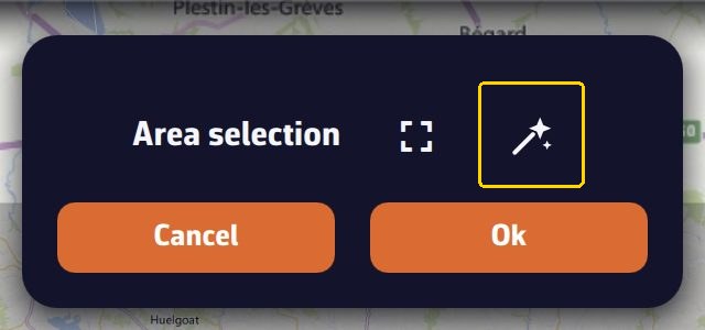 “Area selection” banner: the magic wand, outlined in yellow, is to the right of the full-frame icon, above the “Cancel” and “OK” buttons
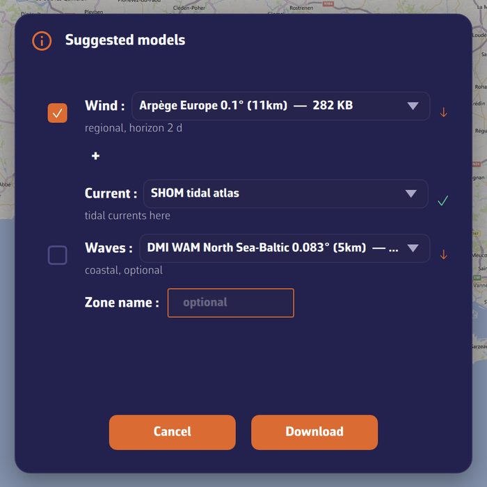 “Suggested models” window opened by the magic wand on an area of Brittany: a wind model, the SHOM current atlas, a wave model and the name of the area
Model description and coverage
In the download window, the small triangular button on the “Model description and map coverage” row unfolds a small map, framed on the chosen model, where the area it covers is drawn in cyan, and below it a text presenting the model. This text comes from the catalog and only exists in English. The map shows the coverage of the model, not the area you have selected.
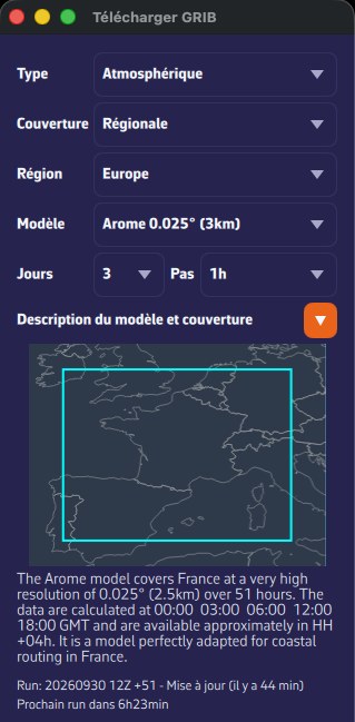 Download GRIB window on the Arome model: description unfolded, coverage drawn in cyan, Run and next run line
Model status
Under the description, the line “Run: … - Updated (… ago)” gives the latest available run and its age, and “Next run in…” the time before the next one. If NavimetriX could not reach the status server, it shows “No update info available”.
The “Models Status” link, at the top of the GRIBs tab of the left drawer, opens in your browser the page that gives the time of the latest runs of all models.
Without a Premium subscription
Without Premium, the download window only offers the “Atmospheric” type, the “Global” coverage and the GFS models. All the other models (ECMWF, ICON, the regional, ensemble, wave, current and ASCAT models) require the Premium subscription. See Installation, account and subscription.