Download a GRIB
BeginnerThe essentials
A GRIB is downloaded for an area that you draw on the chart. You then choose the model, the number of days, the time step and the parameters, and NavimetriX prepares the file on our servers before downloading it. An Internet connection is required.
- Move and zoom the chart to your sailing area.
- Tap the round orange + button at the bottom right, then “Download GRIB”.
- A green rectangle appears on the chart, with the “Area selection” banner at the top of the screen. Adjust the area with the handles, then tap “OK”.
- In the “Download GRIB” window, choose the “Type”, the “Coverage”, the “Region” and the “Model”. When in doubt, keep the proposed values for “Days”, “Timestep” and the parameters.
- Tap “Download GRIB”. The file is displayed on the chart as soon as it has arrived, and joins the “GRIBs” tab of the left drawer.
To go faster, the magic wand in the “Area selection” banner chooses the models for you (see below).
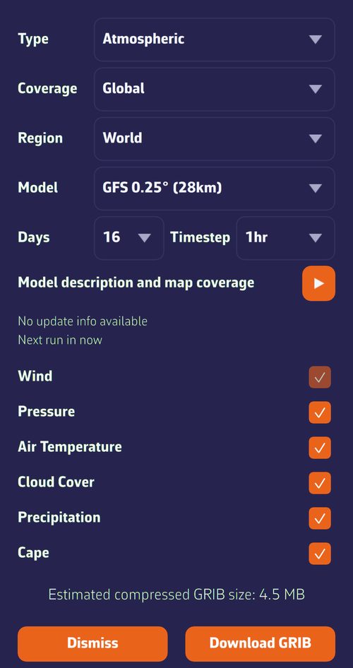 Download GRIB window: type, coverage, region, model, days, step, parameters and estimated size
Going further
Drawing the area
The starting rectangle covers four fifths of the visible part of the chart. The handles at the corners and at the midpoints of the sides resize it; the central handle moves it as a block. The rectangle is green, or sky blue in colorblind mode. The full-screen button in the banner resets it to the current view of the chart, and “Cancel” abandons.
Except for an ocean crossing, take an area a little wider than your sailing area: the wind that will matter to you tomorrow often comes from outside. There is no point in going too wide with a fine model, though: the file grows quickly.
Choosing the model
- “Type”: “Atmospheric”, “Currents”, “Sea State”, “Ensemble” or “Observations (ASCAT)”.
- “Coverage”: “Global” or “Regional”.
- “Region”: “World”, “Europe”, “Americas” or “Other”.
- “Model”: the model name with its grid spacing, for example “ECMWF IFS 0.25° (28km)”.
With regional coverage, only the models that touch your area are offered. If the area is entirely outside the chosen model, the download is refused; an area that partly overflows is accepted. NavimetriX remembers your last choices of type, coverage, region and model.
The triangular button on “Model description and map coverage” unfolds the model’s coverage map and its presentation. Below it, the “Run” line shows the latest available computation and “Next run in…” the time before the next one. See Understanding GRIBs and choosing a model.
Days and step
- “Days” offers from 1 day up to the maximum forecast range of the model. The maximum is what is selected when the window opens.
- “Timestep” offers 1 h, 3 h, 6 h, 12 h or 24 h, without going below the finest step of the model. NavimetriX takes the last step used if it is available, otherwise the finest.
Reducing the days or widening the step makes the file lighter, useful with a slow or satellite connection.
Parameters
One checkbox per family of parameters, if the model contains it: “Wind” (gusts included), “Pressure”, “Air Temperature”, “Cloud Cover”, “Precipitation”, “Cape”, “Waves”, “Currents”. All are ticked when the window opens. The first in the list (wind for an atmospheric model, currents for a current model, waves for a wave model) stays ticked and greyed out: it is the data that makes the file worthwhile. Untick the others to lighten the download. This choice is not remembered from one time to the next.
Size, limits and memory
- At the bottom of the window, “Estimated compressed GRIB size:” updates with each setting, then “Actual GRIB size:” once the server has prepared the file. A size of several tens of MB most often signals a grid that is too fine for the area, too many days or too many parameters.
- A file cannot exceed 300 MB. Beyond that, the estimate turns red with the mention “⚠ May exceed 300 MB download limit”, and a download that exceeds this size is interrupted.
- On a device with less than 3 GB of RAM, a GRIB estimated at more than 50 MB is refused with the message “Insufficient RAM for this GRIB size”: reduce the area or the number of parameters.
- An area smaller than two grid cells of the model is enlarged automatically.
- If you already have a GRIB of the same model on the same area, NavimetriX invites you to update it from the list rather than download a second one.
During and after the download
Status messages follow one another: sending the request, preparing the file on the server, downloading with its percentage, then “GRIB file saved”. During the download, “Cancel” interrupts it. The window then stays open: you can follow up with another model on the same area, then “Dismiss”. On a computer, it opens in a separate window; on phones, tablets and in the browser, over the chart.
The last downloaded GRIB is displayed on the chart. If it does not appear, open the layers menu (round orange button at the bottom right) and check that “Color map” and “Particles” (or “Barbs”) are ticked. See Displaying forecasts on the chart.
Suggested models: the magic wand
The magic wand in the “Area selection” banner analyzes the drawn area and opens the “Suggested models” window:
- Wind: the recommended model, with its size, its coverage (regional or global) and its horizon in days. The list offers the other suitable models of the same coverage, and the + button adds other wind models to compare.
- Current: the “SHOM tidal atlas” as first choice when an atlas touches a coastal area, then the suitable current GRIBs, or “None”. See Currents.
- Waves: a wave model, suggested by default for offshore sailing, optional for coastal.
- Zone name: optional, 8 characters at most, shown in front of the name of these GRIBs in the list.
The choice depends on the size of the area, measured by its diagonal: under 100 miles, one day of forecast; up to 250 miles, two days; up to 500, four; up to 1,000, six; up to 2,000, ten; beyond, fifteen. A regional model is preferred as soon as it covers the whole area, with a grid spacing suited to its size and a file of 30 MB at most when possible. A wave model is ticked by default from 350 miles of diagonal; the current is ticked by default, and the SHOM atlas offered, up to 500 miles.
Each row can be ticked or unticked. “Download” fetches the missing files in parallel (all parameters, at the finest step), displays the wind on the chart and keeps the chosen current and waves as the routing sources. If everything is already there, NavimetriX says so with “Suggested models already downloaded”.
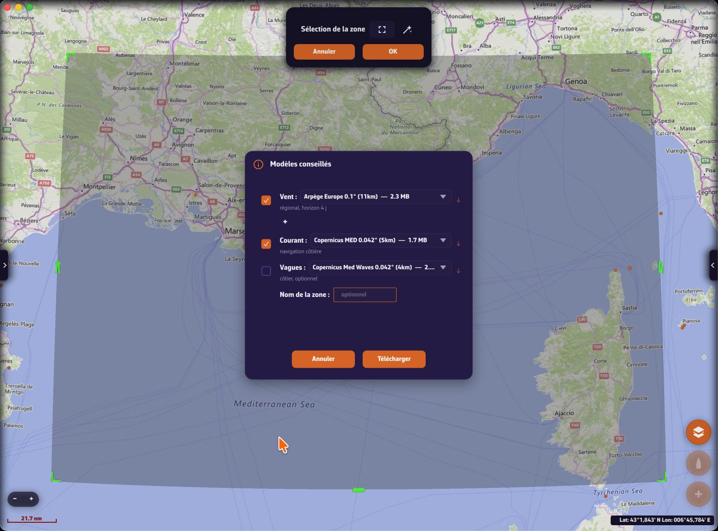 Suggested models window on an area of the Mediterranean: wind, current, waves and zone name
Without a Premium subscription
Without Premium, the window only offers the “Atmospheric” type, the “Global” coverage and the GFS models, with no particular message: the lists are simply shorter. The magic wand then only suggests GFS models for the wind, and the SHOM atlas for the current when it covers the area.