My Boat
BeginnerThe essentials
The My Boat page describes your boat to the app: its name and type, its dimensions, its polar (the table of its speeds according to the wind, which routing needs), and the way it is drawn on the chart when underway.
- Open Settings (handle on the right edge), then “My Boat”.
- Enter the Name and choose the Type: “Monohull”, “Catamaran” or “Trimaran”. The boat icon on the chart follows this type.
- Set the Draft and the Air draft.
- Press the Polar row and choose your boat’s polar. This is the most important setting for routing.
Going further
All these settings follow your NavimetriX account to your other devices.
Identity
 Settings > My Boat: name, type, MMSI, identity, dimensions, AIS broadcast, polar and wind thresholds
| Setting | Use |
|---|---|
| Name | boat name, used by position sharing and the logbook; until you enter it, they have no name |
| Type | Monohull (default), Catamaran or Trimaran; changes the boat icon |
| MMSI | maritime mobile service identity, 9 digits, the one of your VHF or AIS transponder (automatic identification system for ships) |
| Registration, Call sign, Home port | “Identity” section; used at the head of the exported logbook |
Dimensions
- Draft: from 0 to 20 m, in steps of 0.10 m, 2.00 m by default.
- Air draft: from 0 to 100 m, in steps of 0.10 m, 16.00 m by default.
The draft is used by coastal routing on C-MAP charts (avoiding shallows), by C-MAP AutoRouting, by the “Chart dangers ahead (C-MAP)” alarm and by the danger line of the depth instrument. The air draft is used by C-MAP AutoRouting and the “Chart dangers ahead (C-MAP)” alarm.
AIS broadcast
“Share my position” (off by default) broadcasts the boat’s position every 10 seconds on the NavimetriX network, in the form of an AIS message: other NavimetriX users who display AIS over the Internet see you as an AIS target. It is useful for a boat without an AIS transponder. The position never goes onto the public AIS network.
Conditions: Premium subscription, valid GPS position, no DEMO mode. Without an MMSI entered, the app uses an identifier specific to the device.
Colour
The colour of the boat icon in Navigation mode, red by default.
Polar and wind thresholds
- Polar: opens the polar choice (library, import, calculation from the boat’s dimensions…). See the chapter Polars and Sailchart.
- Light wind threshold (from 0 to 30 knots, 10 kt by default) and Strong wind threshold (from 5 to 50 kt, 20 kt by default): below the first, routing applies the “Speed scale under … knots” setting; above the second, the “Speed scale over … knots” setting; between the two, an intermediate value. These efficiencies are set in Settings > “Routing”. The strong wind threshold cannot go below the light wind threshold (the app bounds each by the other); if they are equal, the efficiency switches from one to the other at once, with no transition.
Wind gauge
“Display” (off by default) draws a wind gauge around the boat, in Navigation mode, when the app receives wind: a yellow triangle marks the true wind angle (TWA, the angle between the boat’s axis and the true wind), a cyan line the apparent wind angle (AWA).
COG vector and heading line
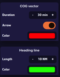 My Boat, COG vector and Heading line sections
- COG vector: a line that starts from the boat in the direction of its course over ground (COG, the real direction of travel), as long as the distance covered during the set Duration at the current speed over ground. Duration from 0 to 300 min (60 min by default), Arrow at the end (on by default), Colour red by default.
- Heading line: a line along the boat’s axis, according to the heading (HDG), of fixed Length: from 0 to 300 NM, in nautical miles (60 NM by default), Colour green by default. It is displayed only if the app receives a heading.
Both lines are displayed only in Navigation mode, with a real GPS position.
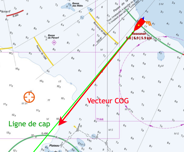 On the chart, the COG vector in red and the heading line in green
Cross track
“XTE limit” (from 0 to 2,000 m, in steps of 10 m, 500 m by default) sets the maximum distance tolerated on either side of the route (XTE: the lateral distance between the boat and the planned route). The cross-track corridor is therefore double: 500 m gives a corridor of 1,000 m. The corridor is displayed in Navigation mode, during a “Goto” or when following a route, from a close enough zoom. It is the same value as the “XTE” setting of the cross-track alarm (Settings > “Alarms”). See the chapter Safety.
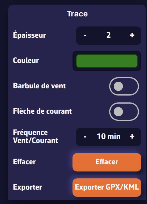
Track
These settings apply to the track being recorded:
| Setting | Values | Default |
|---|---|---|
| Width | from 1 to 5 | 2 |
| Colour | colour chart | dark red |
| Wind barb | wind barbs along the track | on |
| Current arrow | current arrows along the track | on |
| Wind/Current frequency | from 1 to 360 min between two symbols | 10 min |
The Clear button deletes the track being recorded, including on your account, after confirmation (“Are you sure you want to clear the track? This action cannot be undone.”). The rest of the track display is set in the Tracks tab: see the chapter Tracks, replay and logbook.
See also
- General settings
- Polars and Sailchart
- Navigation: GPS, NMEA and AIS
- Record and display the track
- Routing settings and Coastal routing with C-MAP charts
- Navigation alarms
- FAQ: How do I adjust the display of COG and heading vectors?
- FAQ: How to display an XTE (cross-track error) path
- FAQ: How do I display and adjust the track?