General settings
BeginnerThe essentials
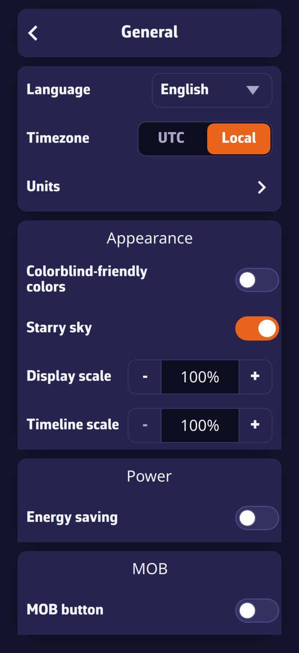 Settings > General: language, time zone, units, then the Appearance, Energy and MOB sections
Settings open with the chevron handle on the right edge of the screen. At the top of the drawer, the Theme is changed with one gesture; just below, the General page gathers the preferences for the whole app: language, time zone, units, appearance, energy, MOB (man overboard) button.
- Open Settings with the handle on the right edge.
- Choose the theme: “Light”, “Dark” or “Night”.
- Press “General” for the language, time zone and units.
- The chevron at the top left returns to the previous page; the handle closes the drawer.
Going further
The drawer’s entries
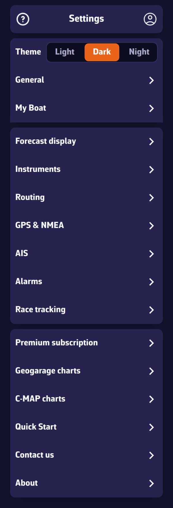 The root of the Settings drawer
| Entry | Content |
|---|---|
| Theme | Light, Dark or Night |
| General | language, time zone, units, appearance, energy, MOB button (this page) |
| My Boat | identity, dimensions, polar, vectors, track (see My Boat) |
| Forecast display | styles, transparencies and isolines of the weather layers |
| Instruments | instrument strip and tiles (Premium) |
| Routing | routing calculation settings |
| GPS & NMEA | position source and connections to the onboard instruments |
| AIS | AIS target settings (Premium) |
| Alarms | navigation alarms |
| Race tracking | tracking a race |
| Premium subscription | the subscription window |
| Geogarage charts, C-MAP charts | nautical chart accounts and zones |
| Quick Start | opens the getting-started guide |
| Contact us | write to support |
| About | version, usage statistics, version history |
In the browser version, the “GPS & NMEA”, “Geogarage charts”, “Alarms” and “C-MAP charts” pages do not exist.
Theme
- Light, Dark (default) or Night.
- The Night theme draws the interface in red and amber on a black background, with low brightness, to preserve night vision at the chart table.
- The theme is specific to each device: light in the cockpit, night at the chart table, without one imposing its choice on the other.
General page
| Setting | Values | Default | Scope |
|---|---|---|---|
| Language | English, French, German, Spanish | the system language at first launch (English if it is not offered) | device |
| Time zone | UTC, Local | Local | account |
| Units | sub-page, see below | account | |
| Colorblind-friendly colors | on, off | off | account |
| Starry sky | on, off | on | device |
| Display scale | from 60 to 200% | 100% | device |
| Font (Windows only) | from 75 to 250%, in steps of 25% | the Windows scale | device |
| Timeline scale | from 100 to 500%, in steps of 100% | 100% | device |
| Energy saving | on, off | off | device |
| MOB button | on, off | off | account |
“Device”: the setting stays on this device. “Account”: it follows your NavimetriX account to all your devices (see Synchronisation between devices).
Time zone. Times are shown in universal time (UTC) or in the device’s local time.
Colorblind-friendly colors. The colours that carry meaning (green and red of states, port and starboard, “now” cursors, AIS danger, wind scale) switch to a palette readable by people who confuse red and green. For example, the GPS quality icon changes from green to blue. This setting follows the person, so the account.
Starry sky. Purely decorative: stars, atmosphere halo, sun, moon and planets around the globe when you zoom out. Turning it off also relieves a struggling graphics processor.
Display scale. Enlarges or reduces the chart and what it carries, from 60 to 200%, handy for reading the chart without glasses. The menus keep their size.
Font (Windows). Enlarges or reduces the texts and menus of the whole app, from 75 to 250%. The change takes effect when the app is restarted.
Timeline scale. Stretches the time bar: the larger the value, the more room an hour takes there, and the finer the jump on touch, from 1 h at 100% to 5 min at 500%. See The main screen.
Energy saving. Spaces out GPS, instrument and alarm updates, and replaces animated particles with barbs and arrows. See Operating modes. Absent from the browser version.
MOB button. Shows the man overboard button at the bottom left of the chart, in Navigation mode with a GPS position. See the chapter Safety.
Units
Settings > “General” > “Units”:
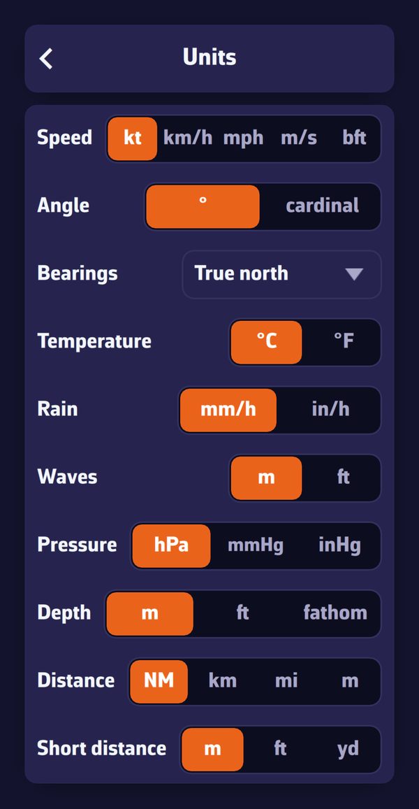 Settings > General > Units
| Unit | Choices (the first is the default) |
|---|---|
| Speed | kt, km/h, mph, m/s, bft (Beaufort scale) |
| Angle | ° (degrees), cardinal (cardinal points) |
| Bearings | True north, Magnetic |
| Temperature | °C, °F |
| Rain | mm/h, in/h |
| Waves | m, ft |
| Pressure | hPa, mmHg, inHg |
| Depth | m, ft, fathom |
| Distance | NM (nautical miles), km, mi, m |
| Short distance | m, ft, yd |
Bearings. This setting applies to bearings to a route point, a POI (point of interest) or an AIS target (a vessel received by AIS), to measurements and to the headings of route legs. They are written “°T” in true north, “°M” in magnetic, then corrected for magnetic declination.