Man overboard (MOB)
BeginnerThe essentials
The MOB (Man Overboard) button marks in a single gesture the position where a person fell into the water. NavimetriX then starts a timer, sets a course for that point and estimates the person’s drift from wind and current.
The button only appears in Navigation mode (reserved for the Premium subscription), with a GPS position.
- Before setting off, open Settings (“‹” handle at the right edge), then “General”: in the “MOB” section, turn on “MOB button”. It is off by default.
- When navigating, a round “MOB” button is displayed at the bottom left of the chart.
- In case of an accident, hold the button pressed for 1.5 seconds: a ring fills around it, then the MOB is triggered. A short tap only displays “Hold to activate MOB”, to avoid any accidental triggering.
- Steer toward the position shown in the red banner at the top of the chart: bearing (“BRG”) and distance (“DST”).
- Once the person has been recovered, hold “Hold to cancel MOB”, at the bottom of the banner, for 1.5 seconds.
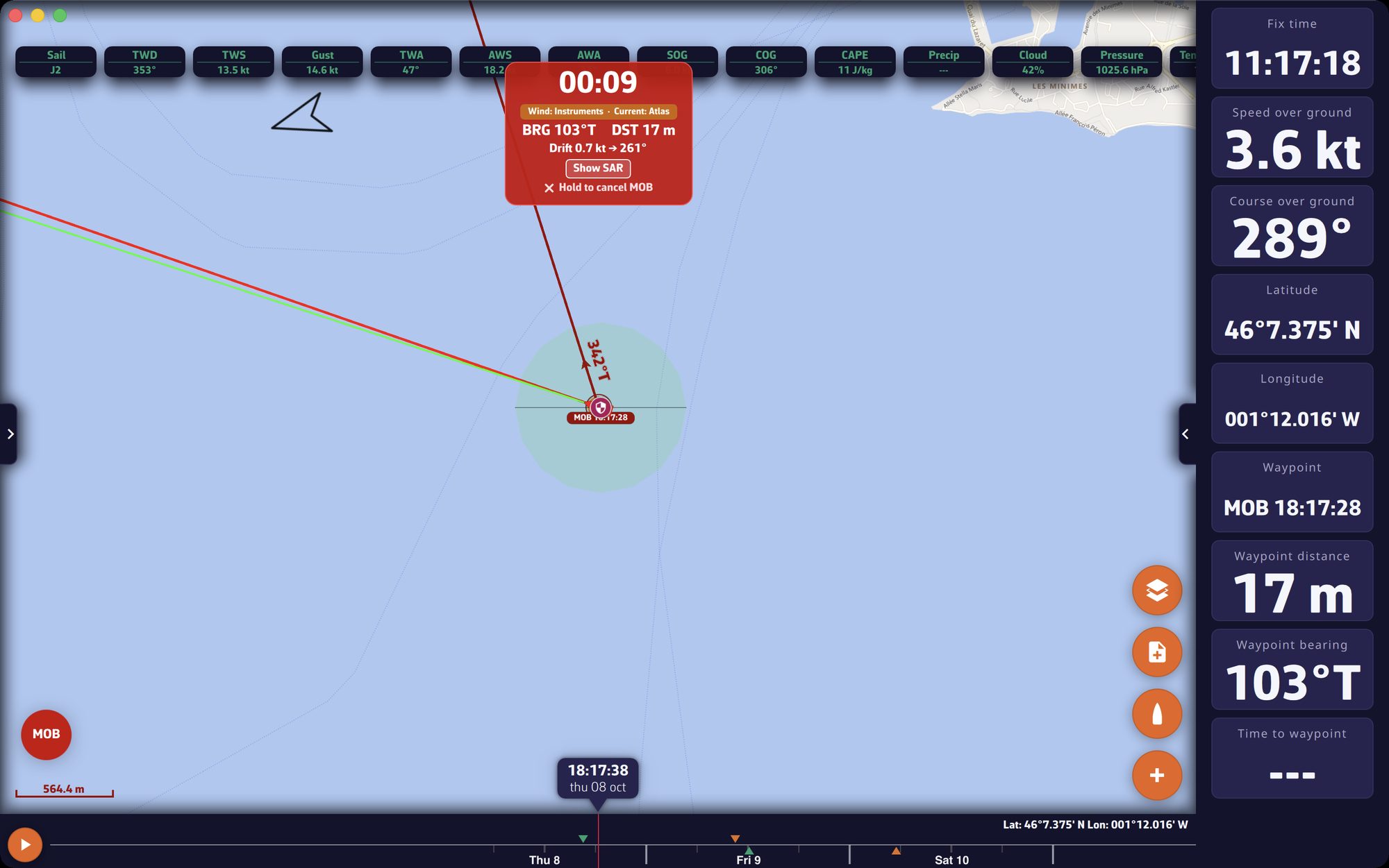 Chart just after a MOB: red banner with timer, bearing and distance, “MOB” POI, route line to the point, drift zone and MOB button at the bottom left
Going further
What triggering does
As soon as the MOB is triggered:
- a “MOB hh:mm:ss” POI is created at the boat’s GPS position;
- this point becomes the destination of a “Goto”, with a route line from the boat;
- the chart centers and zooms on the point;
- a timer starts (minutes and seconds);
- a “Safety event” entry, of type “Man overboard”, is added to the logbook of the current track, at the time and position of the MOB;
- drift estimation begins.
During the MOB, the button turns red and pulses. If an anchor alarm was displayed, its banner steps aside to make room for the MOB banner; the anchor watch continues underneath.
The MOB banner
The red banner, at the top of the chart, gives:
- the elapsed time since triggering;
- a badge that indicates where the estimate comes from: “Wind: GRIB” or “Wind: Instruments”, “Current: GRIB”, “Current: Atlas” or “Current: Instruments”. It is orange when drift data exists, gray with “NO DRIFT DATA”, green with “AIS TRACKING” when an AIS beacon is being tracked (blue in color-blind mode), red with “AIS LOST”;
- “BRG”, the bearing of the point to reach, and “DST”, its distance, in meters under 0.1 mile and in miles beyond;
- “Drift”: speed in knots and the direction toward which the person is drifting;
- the “Show SAR” / “Hide SAR” button;
- “Hold to cancel MOB”.
The estimated drift
A person in the water drifts under the effect of current and wind. Every 30 seconds, NavimetriX recalculates the person’s probable position:
- the wind: that of the loaded GRIB file (the weather forecast file), otherwise the true wind from the instruments. Wind drift is 3% of the true wind speed, downwind, offset by 10°. These are the reference values in maritime search and rescue manuals (IAMSAR) for a person in the water;
- the current: that of the GRIB if it contains one, otherwise that of the current atlases, otherwise the current computed by the instruments.
On the chart, an orange line links the point of the fall to the estimated position, surrounded by an orange circle whose radius grows with time (about 0.1 mile per minute) to represent uncertainty. When drift data exists, the “Goto” follows the estimated position. Loading a GRIB of the area before setting off therefore improves the estimate (see Weather: GRIB files and forecasts).
The search pattern
“Show SAR” draws an expanding square search pattern, the method from the international search and rescue procedures (SAR): legs of increasing length, spaced 0.1 mile apart, with 90° turns to starboard, 20 legs in all. It is centered on the person’s estimated position.
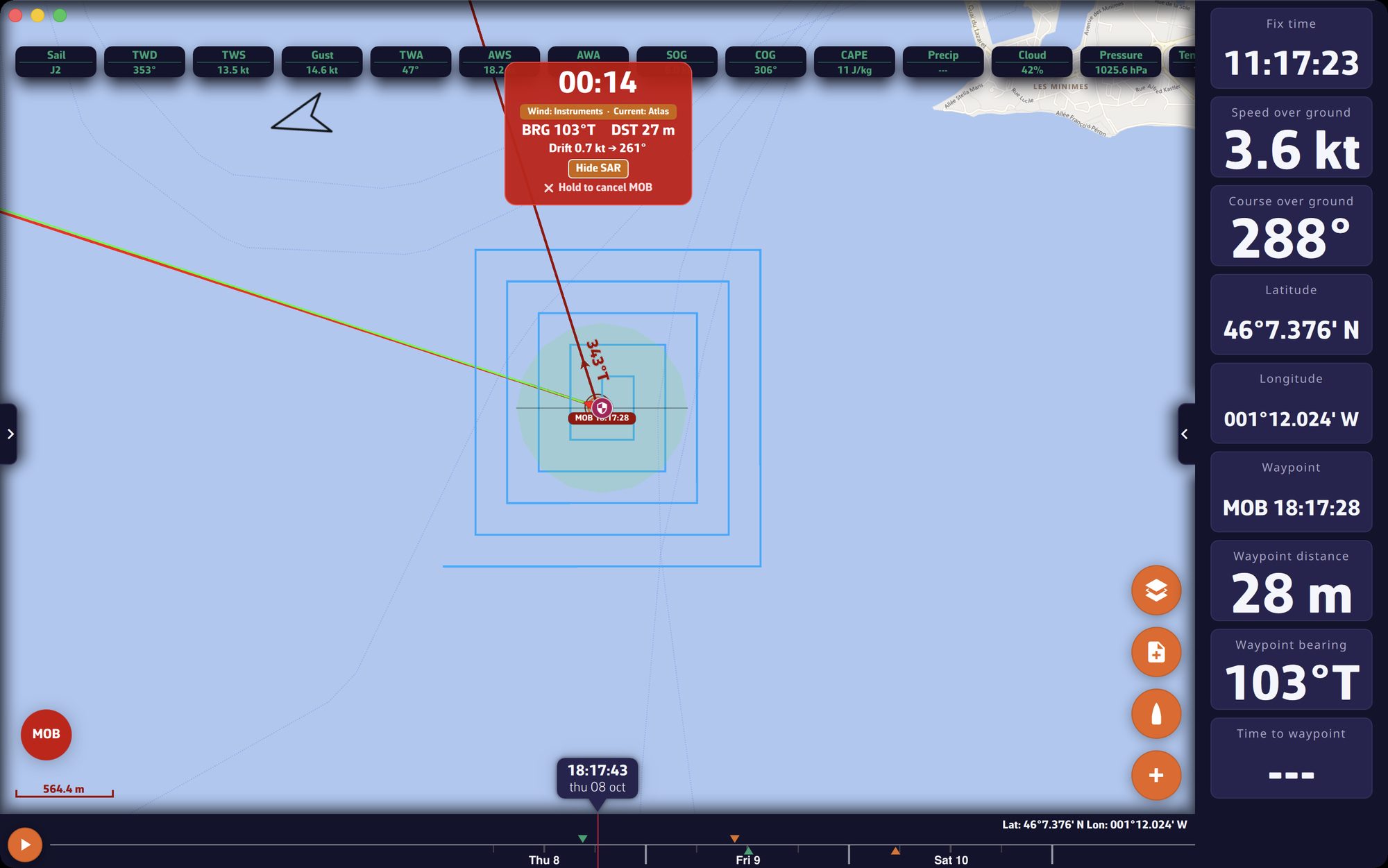 Expanding square search pattern displayed around the MOB position, banner with “Hide SAR”
The MAYDAY reminder
One minute after triggering, if no AIS beacon locates the person, a yellow reminder is displayed in the banner: “MOB not located? Consider MAYDAY on VHF Ch16”.
AIS MOB beacons
An AIS distress beacon transmits the person’s position on the AIS network. NavimetriX recognizes beacons whose MMSI number (the AIS identifier) starts with 970 (AIS-SART), 972 (AIS MOB) or 974 (EPIRB-AIS). As soon as such a beacon is received with a position, in Navigation mode:
- the “MOB Alert” alarm sounds (siren) with the beacon’s position;
- a MOB POI is created and becomes the destination of the “Goto”;
- MOB mode turns on if it was not already on, and the beacon’s position is re-read every 5 seconds;
- if the beacon is no longer received for one minute, NavimetriX goes back to the drift estimate from its last position.
This detection does not require the “MOB button”, but AIS must be received, for example by a receiver connected over NMEA (see Navigation: GPS, NMEA and AIS). The alarm’s “Acknowledge” button recenters the chart on the beacon.
Canceling the MOB
“Hold to cancel MOB” stops tracking, removes the “Goto” destination and hides the banner. The “MOB” POI stays on the chart and the logbook entry is kept.