Routing settings
ExpertThe essentials
The routing settings adjust the calculation to your boat and to the way you sail. They are in two places, which show the same values:
- in the right drawer “Settings”, “Routing” section;
- in the “Routing” window, “Other settings” row.
They are shared between the devices of your account. The default values are fine for a first routing. The three settings that change the result the most are the polar efficiencies, the minimum upwind angle and the manoeuvre penalties.
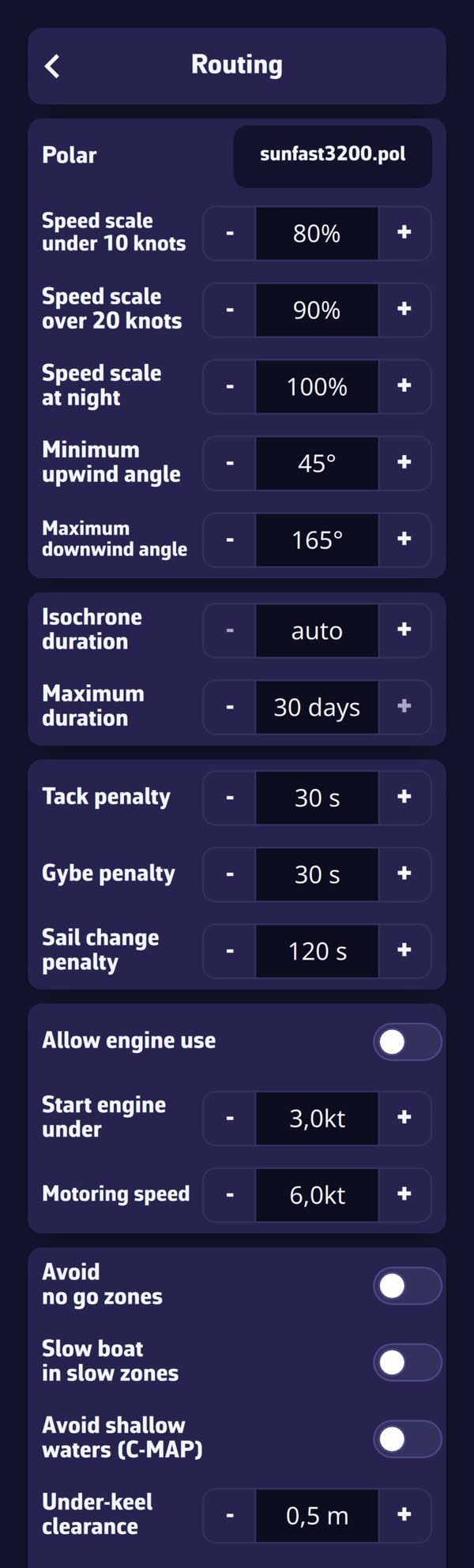 The “Routing” section of the settings drawer
In percentage fields, a value below 100% is shown in red and a value above in green.
The wind, current and wave GRIBs, and their percentages, are not here: they are chosen in the “Routing” window (see Start a routing).
Going further
Polar and efficiencies
| Setting | Values | Default |
|---|---|---|
| “Polar” | a polar from the library or imported | sunfast3200.pol |
| “Speed scale under 10 knots” | 60 to 160% | 80% |
| “Speed scale over 20 knots” | 60 to 160% | 90% |
| “Speed scale at night” | 60 to 160% | 100% |
| “Minimum upwind angle” | 0 to 70° | 45° |
| “Maximum downwind angle” | 130 to 180° | 165° |
- Polar: the same as in “Settings”, “My Boat”. To choose or create it, see Polars and Sailchart.
- Efficiencies (the “Speed scale” rows): most polars are theoretical and optimistic. The efficiency multiplies the polar’s speeds. The first applies below the light wind threshold, the second above the strong wind threshold; between the two, the app moves from one to the other in proportion to the wind. The two thresholds (10 and 20 knots by default) are set in “My Boat”, under the polar (“Light wind threshold”, “Strong wind threshold”), and the row labels follow their values.
- Night efficiency: during nautical night, from nautical dusk to nautical dawn, it is multiplied with the efficiency above. Night is calculated for the position and time of each point of the routing. Useful if you reduce sail at night. Efficiencies combine by multiplication: wind-based efficiency × night efficiency × slow-zone factor. For example, with an efficiency of 90% and a night efficiency of 90%, at night the efficiency is 90% × 90% = 81%.
- Minimum upwind angle: the routing does not make the boat point closer to the wind than this angle, even if the polar allows it. Count on 40° with a full crew and 45° when singlehanded or cruising.
- Maximum downwind angle: the routing does not make the boat sail deeper than this angle, to avoid dead downwind and accidental gybes.
Isochrones and duration
| Setting | Values | Default |
|---|---|---|
| “Isochrone duration” | auto, or 5 to 360 min in steps of 5 | auto |
| “Maximum duration” | 1 to 30 days | 30 days |
The auto step mode is detailed in Routing principles and isochrones. Without a Premium subscription, the duration of a routing is limited to 2 days, whatever this setting.
Manoeuvre penalties
| Setting | Values | Default |
|---|---|---|
| “Tack penalty” | 0 to 600 s, in steps of 5 | 30 s |
| “Gybe penalty” | 0 to 600 s, in steps of 5 | 30 s |
| “Sail change penalty” | 0 to 600 s, in steps of 10 | 120 s |
A penalty is the time lost by a manoeuvre: during this time, the boat does not advance along its route (it keeps drifting with the current). Without a penalty, the router would tack as soon as the gain is positive, however small; with a penalty, it prefers fewer, longer boards. Enter the real time it takes you, crew included, to manoeuvre and regain speed.
The sail change penalty only applies if your polar has a Sailchart (the table that says which sail to carry according to the wind): without it, the routing does not know the sails. It is added to that of a tack or gybe made at the same time. Staying within a band where the sail carried is still allowed does not count as a change.
Engine
| Setting | Values | Default |
|---|---|---|
| “Allow engine use” | yes or no | no |
| “Start engine under” | 0 to 30 knots, in steps of 0.1 | 3.0 knots |
| “Motoring speed” | 0 to 30 knots, in steps of 0.1 | 6.0 knots |
With the engine allowed, the routing starts the engine where the sailing speed falls below the threshold, and the boat then moves at the motoring speed. The engine is used only to head for the finish: within 45° of the shortest path over water. Legs under engine are shown dotted on the chart. Without the engine, a calm can stop the calculation (“there is not enough wind to sail and the motor is disabled”).
Zones
| Setting | Default |
|---|---|
| “Avoid no go zones” | no |
| “Slow boat in slow zones” | no |
These zones are ZOIs (zones of interest) that you draw on the chart. In a ZOI’s window, the “Zone Type” is “Information”, “No-Go Zone” or “Slow Zone”.
- A no-go zone (traffic separation scheme, wind farm…) is avoided by the routing when the first setting is on.
- A slow zone carries a “Speed Factor (0.0 - 2.0)” that multiplies the boat’s speed inside it, when the second setting is on. A factor above 1 speeds the boat up. This factor is multiplied with the efficiencies described above. If two slow zones overlap, only the first counts.
To create ZOIs, see ZOIs (zones of interest). The settings that follow in this block (shallows, under-keel clearance, tide, distance to dangers, restricted areas, cardinals) require a C-MAP chart: they are described in Coastal routing with C-MAP charts.
Constant wind
| Setting | Values | Default |
|---|---|---|
| “Constant wind” | yes or no | no |
| “Constant wind speed” | 0 to 100 knots | 12 knots |
| “Constant wind direction” | 0 to 359°, in steps of 5 | 180° |
Constant wind replaces the GRIB wind everywhere with a fixed wind, for example the one you read on the anemometer and wind vane. It is used to study the effect of current in a bay or a race. A wind GRIB is not required. If a wind GRIB is selected, the start must nevertheless be within its area and period.
Current
Current is chosen in the “Routing” window, “Current” row: “None”, “SHOM atlases” or a current GRIB, with a percentage from 80 to 150% applied to its speed.
Wind and wave limits
| Setting | Values | Default |
|---|---|---|
| “Heave to over limit” | yes or no | no |
| “Upwind max wind speed” | 15 to 100 knots | 60 knots |
| “Downwind max wind speed” | 15 to 100 knots | 60 knots |
| “Waves max height” | 0 to 30 m, in steps of 0.5 | 6.0 m |
- The upwind limit applies to a wind received less than 90° from the bow, the downwind limit beyond 90°.
- The wave height is that of the total sea (significant height). It only applies if a wave GRIB is chosen in the “Routing” window.
- By default, the routing avoids places where a limit is exceeded. If the whole area ahead of the boat exceeds them, the calculation stops (“the wind is above the maximum wind set in the routing settings everywhere ahead”).
- With “Heave to over limit”, the boat stops (zero speed) while the wind drops back below the limit, instead of making a long detour. On a long passage, a few hours hove to are often better than a detour of several days.
Do not overuse limits: set too low, they prevent the routing from succeeding.
Crossed sea
| Setting | Values | Default |
|---|---|---|
| “Waves min height for crossed sea” | 0 to 5 m, in steps of 0.5 | 2.0 m |
| “Polar crossed sea efficiency” | 0 to 100% | 75% |
There is crossed sea when the wind sea and the swell both exceed the minimum height and their directions are between 45° and 135° apart. The boat’s speed, under sail or engine, is then multiplied by the crossed sea efficiency.
You need a wave GRIB that gives wind sea and swell separately (GFS Wave, MFWAM, Copernicus, DMI WAM). With a file that gives only the total sea, such as ECMWF Wave or IFREMER’s WW3, there is never crossed sea.
Reset
The “Reset routing parameters to default” button, at the bottom of the section, returns this page’s settings to their factory values. Note that it also sets the maximum duration to 16 days and the wind percentage of the “Routing” window to 115%, and turns off current and waves. The C-MAP settings are not touched.