Routing principles and isochrones
BeginnerThe essentials
Weather routing looks for the fastest route between a start and a finish. It combines the wind forecast by a GRIB file (a weather forecast file), your boat’s polar (its speed according to the wind strength and the angle at which it receives it) and, if you choose them, current and sea state.
The calculation advances by isochrones. An isochrone (“same time”) is a line joining all the positions the boat can reach after the same amount of time. The routing chains them step by step to the finish: the optimal route follows from them.
To see a routing’s isochrones:
- Tap the round layers button, at the bottom right of the chart, and tick “Isochrones” in the “Display” section.
- Open the left drawer, “Routings” tab.
- Tap (or click) the routing you want: an orange bar appears on its left and its isochrones are displayed on the chart.
- Tap it again to hide them.
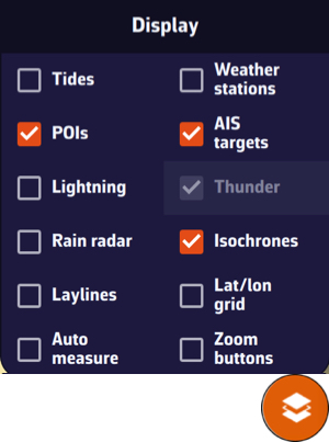 The “Isochrones” checkbox in the “Display” section of the layers menu
Isochrones are displayed for only one routing at a time, the selected one. A routing that has just finished is selected automatically and the “Routings” tab opens.
Going further
How the calculation advances
NavimetriX uses the isochrone method: at each time step, the app draws the curve of the positions the boat can reach after the same amount of time, starting from the start.
The calculation respects your settings: polar efficiencies, upwind and downwind angles, tack, gybe and sail change penalties, engine, no-go zones and slow zones, wind and wave limits and, with a C-MAP chart, shallows and buoyage. All these settings are described in Routing settings and Coastal routing with C-MAP charts.
During the calculation
The isochrones appear on the chart as the calculation proceeds. The chart follows the isochrone front and the timeline advances with it, at most twice a second. At the top of the chart, the “Cancel routing” button stops the calculation. Under this button, a label says what the routing is doing when nothing is moving yet on the chart: “Initializing the routing…”, “Preparing the C-MAP charts…” (with a percentage) or “Polishing the route…”.
At the end, a window gives the result, for example “Reached destination”, or the reason for stopping.
What the isochrones show
- The isochrones are drawn in blue.
- On each isochrone, a blue dot marks the point through which the best route passes. If the route does not pass through it, it is the point closest to the finish, in distance over water. These points serve as pivot points to test another route option: see Study your routing and pivot points.
- Where the route crosses an isochrone, and at the start, the finish, the waypoints and the tacks and gybes, a dot and a wind barb mark the route. How to read them is detailed in Read a routing.
The isochrone step
The step is the time between two isochrones. It is set in the right drawer “Settings”, “Routing” section, “Isochrone duration” row: “auto” by default, or a fixed value from 5 to 360 minutes, in steps of 5 minutes.
In auto mode, the step is short at the start and lengthens along the passage:
| Time since the start | Step at most |
|---|---|
| First hour | 20 min |
| Up to 24 h | 1 h |
| Up to 48 h | 1 h 30 |
| Up to 72 h | 2 h |
| Up to 5 days | 3 h |
| Beyond | 6 h |
The step is also shortened on short route legs. For a routing from a pivot point, the count restarts from the pivot point. We strongly advise keeping auto mode: reducing the isochrone time step does not necessarily calculate a better routing. A fixed step that is too short can stop the calculation with the message “Routing calculation stopped as it reached the maximum number of isochrones before the destination. Set the isochrone duration to auto.”
Routing duration
The “Maximum duration” setting (“Routing” section of the settings) limits the duration covered by the routing, from 1 to 30 days (30 by default). The routing also stops at the end of the GRIB file’s forecasts.
Without a Premium subscription, a routing covers at most 2 days. Beyond that, the calculation stops with the message “Routing calculation stopped as we reached the routing max duration of 2 days for non Premium users”.
When the calculation stops before the finish
The end message gives the cause. The most frequent:
- “the boats left the area covered by the wind GRIB”: download a GRIB that covers the whole route;
- “the most recent isochrone is empty”: most often the route passes too close to land or to a constraint; modify the route or relax the wind and wave limits;
- “there is not enough wind to sail and the motor is disabled”: allow the engine or change the start time;
- “every way forward is blocked by land”, “by no-go zones” or “by shallows or restricted areas of the C-MAP chart”;
- “we reached the end of the weather forecast”.
If a mandatory waypoint is on land, the app flags it and recentres the chart on that point when you close the message, so that you can move it.