Coastal routing with C-MAP charts
ExpertThe essentials
Warning: the skipper, as master of the vessel, remains solely responsible for their navigation. Routing is only an aid. Check your route, then check it again, before setting off. Never rely on a routing without having checked it yourself on the chart.
With a C-MAP chart (DISCOVER X or REVEAL X), the routing reads the chart: it goes only where your boat floats, keeps its distance from dangers and respects the buoyage. The options are in “Settings”, “Routing” section, in the zones block.
- Enter your boat’s “Draft” in “Settings”, “My Boat” (2.00 m by default).
- In “Settings”, “Routing”, turn on “Avoid shallow waters (C-MAP)”.
- Check the “Under-keel clearance” and the “Min distance to dangers”.
- Leave “Use the tide for the depth”, “Avoid restricted areas (C-MAP)” and “Pass cardinals on the right side (C-MAP)” on.
- Start the routing as usual (see Start a routing).
Before the isochrones, the “Preparing the C-MAP charts…” label shows a percentage: the app is preparing the depths of the route’s area.
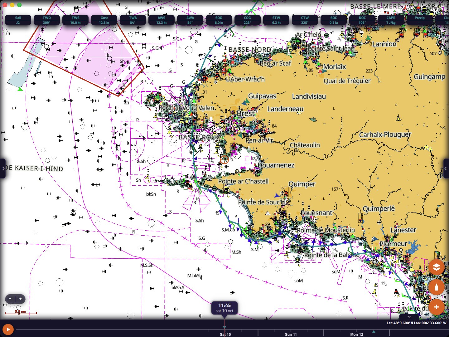 A routing from La Trinité to Cherbourg with “Avoid shallow waters (C-MAP)”: Raz de Sein, Pointe Saint-Mathieu and the Chenal du Four
These options exist only on devices where C-MAP is available: iPhone and iPad, Android, macOS, Windows and Linux, not in the browser version. On iPhone and iPad, the “Enable C-MAP” switch in the iOS Settings app must be on. To buy a chart and download your zones, see C-MAP charts: purchase, account and zones.
Going further
The settings
| Setting | Values | Default |
|---|---|---|
| “Avoid shallow waters (C-MAP)” | yes or no | no |
| “Under-keel clearance” | 0 to 5.0 m, in steps of 0.1 | 0.5 m |
| “Use the tide for the depth” | yes or no | yes |
| “Min distance to dangers” | 0 to 500 m, in steps of 10 | 30 m |
| “Avoid restricted areas (C-MAP)” | yes or no | yes |
| “Pass cardinals on the right side (C-MAP)” | yes or no | yes |
The other five settings affect the calculation only if “Avoid shallow waters (C-MAP)” is on. The distance to dangers is shown in your short-distance unit.
Avoid shallows
The router reads land, depth areas, rocks, wrecks and obstructions from the C-MAP chart. A route segment is accepted only if the depth found along its whole length is at least equal to the draft plus the under-keel clearance. The chart is read finely near coasts, banks and ports, and more coarsely offshore, where there is water everywhere.
The minimum distance to dangers widens this caution: nothing within this distance of a segment may be shallower than the boat needs. Near a waypoint of your route (a departure port, a finish set against the coast), the chart is read without this margin, over twice the chosen distance, otherwise the route could never leave or enter it.
The tide in the depth
The chart’s soundings are given relative to chart datum. With “Use the tide for the depth”, the router adds to the sounding the lowest water height forecast during the leg, at the nearest tide station. A passage that dries at low water can thus be used at mid-tide.
- The tide is taken into account over the first 5 days of the routing at most; beyond that, the sounding is taken as is.
- If no tide station is close enough, the sounding is taken as is.
Not counting the tide is always on the safe side.
Restricted areas
With “Avoid restricted areas (C-MAP)”, the chart areas where entry is prohibited, restricted or to be avoided (wind farms, firing areas…) are treated like land.
Cardinals, isolated dangers and lateral buoyage
With “Pass cardinals on the right side (C-MAP)”, the router adds to the chart’s dangers:
- a 0.2 NM band on the danger side of each cardinal mark;
- a 0.1 NM circle around each isolated danger mark;
- a 0.1 NM band on the outer side of lateral marks, where the chart gives the direction of buoyage, and the edges of buoyed channels, which link marks on the same side.
Channel edges do not count within one mile of a waypoint of your route: a port at the edge of a channel must be able to be left or reached by crossing it.
Course marks become gates
This applies with or without a C-MAP chart. In a route, a point can be “Pass through this point”, “Leave to port” or “Leave to starboard” (see Create and edit a route).
A mark to be left to port or to starboard does not pull the route onto itself: it becomes a gate, a half-line starting from the mark on the side where you must pass. The route must cross all the gates, in order and on the correct side, and can round the mark as widely as the wind requires.
Sharp turn: rounding a mark caught in a turn of 55° or less between the two segments makes the routing take a detour. At launch, the app flags it: “Sharp turn at … Rounding such a mark makes the routing take a detour. Turn it into a waypoint?”
- “Pass through and calculate” turns the mark into a waypoint in the route, then starts the calculation.
- “Keep and calculate” keeps the mark as it is.
A mark placed on a chart danger cannot become a waypoint: it remains a mark to be rounded, and the message says so.
When the chart could not be read
The router prepares the depths from your C-MAP zones and the C-MAP chart server. At the end of the calculation, if the chart could not be read over part of the route covered by your charts, the result window says so: “The C-MAP chart could not be read over … of the route. Over this portion, the route was NOT checked against depths and dangers.” It gives the cause:
- the chart is one of yours but the zone is not downloaded on this device: download it, then restart the calculation;
- the zone is downloaded but the chart server did not respond: restart the calculation.
In waters that are not part of your charts, nothing is flagged: the route is simply not checked against depths there.
Messages specific to coastal routing
- “Routing impossible: the start (or the finish) is on land or in too little water for the draft on the C-MAP chart.”: move the point to deeper water.
- “Routing impossible: no passage through the water was found between the start and the finish.”: place them in open water, or check the draft and the safety distance.
- “Routing calculation stopped as every way forward is blocked by shallows or restricted areas of the C-MAP chart.”: reduce the distance to dangers, check the draft, or modify the route.
Limits
- Ensemble routing never reads the C-MAP chart, even with these options on.
- The final, polished route is also subject to these constraints.
- Coastal routing does not replace lookout or reading the chart: it only knows what the chart contains.
The routing’s route report gives, leg by leg, the water depth, the water under the keel, the nearest danger and the tide: see Read a routing. To simply plot a safe path between waypoints, without weather, see C-MAP AutoRouting.
See also
- Routing settings
- Start a routing
- Read a routing
- C-MAP charts: purchase, account and zones (C-MAP charts: purchase, zones, settings)
- Tides (tides)