ZOIs (Zones of Interest)
BeginnerThe essentials
A ZOI (Zone Of Interest) is a polygon drawn on the chart. There are three types:
- “No-Go Zone”, drawn in red: traffic separation scheme (TSS), wind farm, protected area, area excluded by the sailing instructions… Routing can avoid it.
- “Slow Zone”, drawn in orange: sargassum field, speed-limited area, dangerous sea… Routing can reduce the boat’s speed in it.
- “Information”, drawn in blue: an area to flag, with no effect on routing.
To create one:
- Tap the round orange “+” button, then “Create ZOI”. On a computer, you can also right-click on the chart, then “Create ZOI”.
- Tap the chart to place the vertices of the outline, at least three.
- Tap “Finish” in the top banner.
- In the “Save zone” window, enter the “Zone name”, choose the “Zone Type” and, if you wish, a comment. Confirm with “OK”.
ZOIs are stored in the “ZOIs” tab of the left drawer.
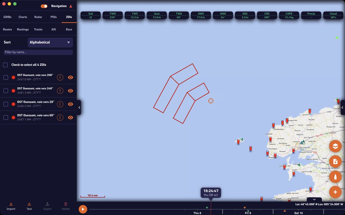 “ZOIs” tab of the left drawer and the lanes of the Ushant traffic separation scheme drawn in red on the chart
Going further
The zone window
| Field | Purpose |
|---|---|
| “Zone name” | Name displayed in the list. |
| “Zone Type” | “Information”, “No-Go Zone” or “Slow Zone”. |
| “Speed Factor (0.0 - 2.0)” | Slow zones only. Coefficient applied to the boat’s polar speed in the zone: 0.5 halves the speed. 1.0 by default. |
| “Comment” | Free text, for all types: sailing instructions reference, times, instructions… |
Edit a ZOI
Tap (or click) a ZOI’s outline on the chart, then “Edit zone” or “Delete zone”.
- When editing, drag a vertex to move it, or tap the outline to add an intermediate vertex. Tap a vertex (right-click on a computer) then “Delete point” to remove it.
- The sides must not cross: NavimetriX refuses a polygon whose sides intersect and asks you to move the points.
- After “Finish”, the zone window reopens: you can change the name, type, speed factor and comment.
The ZOIs tab
- “Sort”: “Alphabetical”, “Distance ↑” or “Date added”. The “Filter by name…” field filters the list.
- Tap a zone to centre the chart on it. The eye shows or hides it. The “⋮” button offers “Rename” and “Delete”.
- Tick zones for the bottom buttons “Export” (“Share” on phones and tablets) and “Delete”. The top box ticks all the listed zones.
ZOIs and routing
Routing only takes no-go zones and slow zones into account, and only if:
- the zone is displayed (eye on in the ZOIs tab): a hidden zone is ignored;
- the matching routing setting is on: “Avoid no go zones” and “Slow boat in slow zones”. Both are off by default. See Routing settings.
Import ZOIs from a file
“Import”, at the bottom of the ZOIs tab, accepts two formats:
- KML (
.kml): each polygon becomes a no-go zone, or a slow zone if the file gives it a polar efficiency below 1. The description becomes the comment. .cl10files (zones exported by Adrena): surfaces become no-go zones; lines (start line, limit) and circles (marks, buoys) become information zones.
Always check the type of each imported zone, and correct it with “Edit zone” if needed.
Import ZOIs from sailing instructions
Sailing instructions often list TSSs and no-go zones as coordinates. Rather than entering them by hand, paste them:
- In the sailing instructions document, copy the passage that describes the zones.
- In the ZOIs tab, tap “Text”. The “Import from Text” window opens.
- Paste the text. Delete unneeded lines and shorten names if necessary: each zone title followed by its points (for example “ZI Cap Finisterre A : 43°31,400N 010°05,150W”) gives one zone.
- Tap “Parse Zones”. The list of zones found appears, with the number of points and the extent of each.
- Tap “Import … Zone(s)”, or “Back” to correct the text.
Zones imported this way are no-go zones. NavimetriX does its best to read the text, but always check the zones on the chart before relying on them. If you had already drawn a zone at the same place, hide or delete it: only the coordinates in the sailing instructions are authoritative.
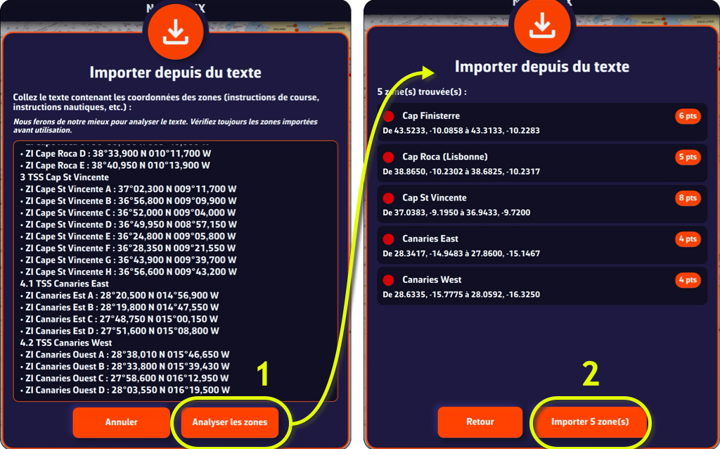 Import from Text: pasted text, Parse Zones, then the list of zones found and Import
Export and share
ZOIs are exported in KML format. On a computer, “Export” opens a save window; on phones and tablets, “Share” opens the system share sheet.
See also
- Routing settings: avoid no-go zones, slow down in slow zones
- Create and edit a route
- FAQ: ZOIs - Zones Of Interest
- FAQ: How do I import ZOIs from sailing instructions?