POI List, Import and Export
BeginnerThe essentials
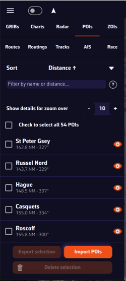 POIs tab: sort, filter, details zoom, list and Import, Export, Delete buttons
All your POIs are stored in the POIs tab of the left drawer. There you find a point, centre the chart on it, hide it, and import or export point files.
- Open the left drawer (chevron handle at the left edge of the screen), then the “POIs” tab.
- Tap a POI’s name to centre the chart on it.
- The eye at the right of a line shows or hides that POI on the chart. The “⋮” button offers “Rename” and “Delete”.
- To import points, tap “Import” at the bottom of the tab and choose one or more GPX, KML or WP files.
- To export, tick the desired POIs then tap “Export” (“Share” on phones and tablets).
Going further
Sort and filter
- “Sort”: “Alphabetical” or “Distance ↑” (from nearest to farthest). The choice is remembered on the device.
- Distance and bearing: with a GPS position, each line shows the POI’s distance in your unit (nautical miles by default) and its bearing from the boat, true or magnetic depending on the units settings, for example “228.4 NM • 249°T”. Without a position, a warning indicates that distance functions are disabled: sorting by distance and filtering by distance no longer work.
- Filter: the “Filter by name or distance…” field keeps the POIs whose name contains the text entered. With a GPS position, it also accepts distances in nautical miles:
| Input | POIs kept |
|---|---|
20 | 20 miles or less away |
>200 | more than 200 miles away |
<50 | less than 50 miles away |
10-100 | between 10 and 100 miles away |
The “?” button at the right of the field recalls these examples.
Import POIs
“Import” accepts three formats, and several files at once:
- GPX (
.gpx), the common exchange format of GPS units and navigation apps; - KML (
.kml), the Google Earth format; - WP (
.wp), the Adrena waypoint format.
A point whose name already exists in your list (case-insensitive) is not imported a second time. The final message gives the number of new POIs and ignored duplicates, as well as unreadable files or files with no valid point.
Export and share
Tick the POIs to export. The top box, “Check to select all … POIs”, ticks them all at once, or only those that pass the filter if a filter is entered.
- On a computer, “Export” opens a save window: choose the GPX or KML format and the file location.
- On phones and tablets, “Share” creates two files, one GPX, one KML, and opens the system share sheet (messaging, email, files…).
Delete several POIs
Tick the POIs then tap “Delete” and confirm. The anchor POI cannot be deleted while the anchor alarm is armed: disarm it first.
See also
- Create and edit a POI
- Import and export routes
- Create and edit a route: a route can be built from your POIs
- FAQ: How to import POIs and routes