Navigate to a POI and Follow a Route
BeginnerThe essentials
NavimetriX can guide you to a POI (“Goto”) or along a route, mark by mark. It then calculates the distance, bearing and cross-track error to the point you are heading for, which can be shown in the instruments and sent to the autopilot. Guidance on the chart requires Navigation mode, reserved for the Premium subscription: turn it on with the “Navigation” switch at the top of the left drawer.
Go to a POI
- Tap (or click) the POI on the chart.
- Choose “Goto”, then confirm “Navigate to … ?”
- To stop, tap the POI again, choose “Stop goto” and confirm.
Follow a route
- Display the route on the chart (the eye in the “Routes” tab).
- Tap the waypoint to start from, then “Follow route, start here”.
- To stop, tap the route, choose “Stop following” and confirm.
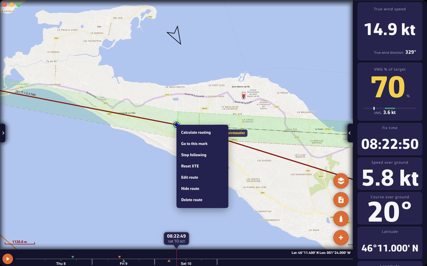 Route following: green cross-track corridor and waypoint menu (Go to this mark, Stop following, Reset XTE)
Going further
Go to a POI
In Navigation mode, a dotted line joins the boat to the POI as long as the boat is at sea. The boat’s position at the time of the “Goto” serves as the starting point for the cross-track calculation. If you edit or move the target POI, the destination follows.
A “Goto” replaces the route following in progress. While following a route, the POI menu therefore always offers “Goto”, never “Stop goto”.
Follow a route
- Start: the boat’s position at launch becomes the origin of the first segment; the first segment therefore starts from where you are, not from where you should have been.
- Automatic switching: NavimetriX moves on to the next waypoint when the boat comes within 0.1 mile of the target waypoint, or when it crosses the perpendicular to the segment through that waypoint (useful if you pass the mark a little wide).
- Change mark: while following, tap another waypoint of the route and choose “Go to this mark”. Following resumes towards that point: to skip an abandoned mark, or to go back to a mark validated too early after a GPS position jump.
- Edit the followed route: following is suspended during the edit, then resumes at the mark reached.
The cross-track corridor (XTE)
The XTE (Cross Track Error) is the distance between the boat and the straight line from the starting point to the target point. In Navigation mode, during a “Goto” or a route following, a corridor is drawn on either side of this line, when the chart is zoomed to harbour view or closer.
- The distance between the line and each edge of the corridor is set in Settings, “My Boat”, “Cross track” section, “XTE limit” line: from 0 to 2,000 m, 500 m by default (1,000 m wide corridor).
- “Reset XTE”, in the route menu during following, starts again from the boat’s current position: the reference line now runs from the boat to the target point.
- An alarm can sound if you leave the corridor: Settings, “Alarms”, cross-track section (see Navigation alarms).
The laylines
Laylines are the two ideal tacking lines to the target point, upwind or downwind, calculated from the wind and the boat’s polar. Green is the starboard tack, red is the port tack. They appear during a “Goto” or a route following, in Navigation mode, when the “Laylines” box in the “Display” section of the layers menu is ticked, and only if the boat is closing on the point (positive VMC, VMC being the speed of approach to the target point). See also the chapter Navigation: GPS, NMEA and AIS.
Lock the target on a POI
The target is the reference point for several chart functions, such as “Route to the target” in the “+” menu. By default, it is the centre of the screen. In a POI’s menu, “Lock target on this POI” fixes it on that POI, even when you move the chart; “Unlock target” puts it back at the centre of the screen. The “Target” list in the layers menu offers the same choices (“Disabled”, “Screen center”, “GPS position” or a POI). Deleting the locked POI brings the target back to the centre of the screen.
Steering the boat
If your autopilot receives NavimetriX’s NMEA data, it can follow the bearing to the target point, then the successive bearings of the route. NMEA output configuration is described in NMEA outputs.