C-MAP AutoRouting
ExpertThe essentials
C-MAP AutoRouting draws a detailed route for you between the points you choose: it goes around land and shallows according to the C-MAP chart, and takes your boat’s draft and air draft into account. It needs C-MAP charts, the “C-MAP” background displayed, and downloaded C-MAP zones that cover each of your points.
- Display the “C-MAP” background (layers menu, “Maps” section).
- Tap the round orange “+” button, then “C-MAP AutoRouting”.
- Tap the chart to place the start, any intermediate waypoints, then the finish.
- Tap “Finish” in the top banner. The “Calculating C-MAP AutoRouting…” window appears during the calculation; “Cancel” interrupts it.
- Give the calculated route a name in “Save route” and confirm. It joins the “Routes” tab.
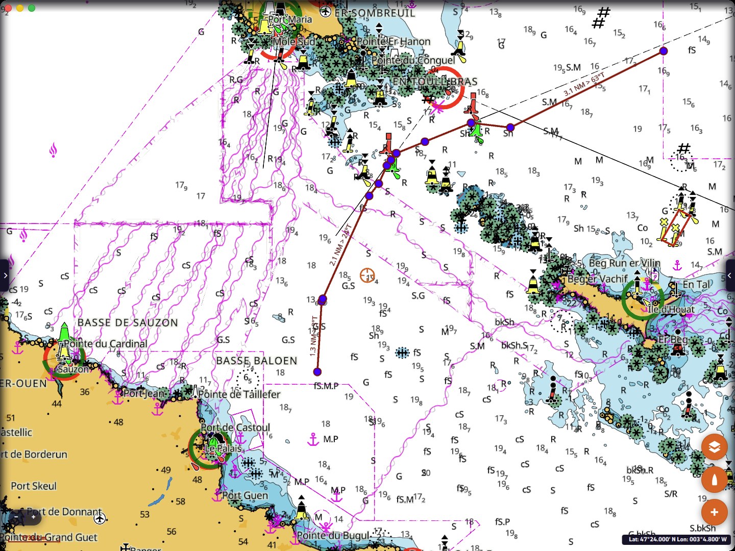 Route drawn by C-MAP AutoRouting from Le Palais to Quiberon Bay, through the Teignouse channel
Going further
Where to find it
“C-MAP AutoRouting” only appears when the “C-MAP” background is displayed. It can be started from:
- the “+” menu;
- a right-click on the chart, on a computer;
- a POI’s menu: the route starts from that POI;
- a route’s menu, on the chart or with the “⋮” button of the “Routes” tab: the existing route is recalculated (see below).
Recalculating an existing route
Started from a route’s menu, AutoRouting takes all of its points as mandatory stops, in order, and calculates the detailed path between them. The result is saved as a new route, offered under the route’s name followed by “(AutoRouting)”. The original route is never modified: the calculated path can be very different, or the calculation can fail.
Draft and air draft
The calculation uses the dimensions entered in Settings, “My Boat”, “Dimensions” section:
- “Draft”: 2.00 m by default;
- “Air draft”: 16.00 m by default. It lets the route avoid bridges and obstacles that are too low.
Check these two values before your first AutoRouting.
Zone coverage
Each point of the route must lie within a C-MAP zone that you have downloaded on this device (see C-MAP charts: purchase, account and zones). Otherwise NavimetriX refuses before even starting the calculation and lists the points concerned (“Route point … is not in a downloaded C-MAP zone”), or reports that the whole route is outside your zones.
The straight line between two points may itself leave the zones: that is precisely what the calculation avoids by going around the land. If the calculation fails for this reason, the message tells you between which points the route leaves your zones: download the missing zone and try again.
The calculation is abandoned if it lasts more than 120 seconds, even if the server still answers that it is in progress (message “C-MAP autoroute timed out after 120 s.”).
The result
The calculated route is an ordinary route: its points are called “Waypoint 01”, “Waypoint 02”… and are all pass-through points. You can edit it, reverse it, follow it or export it like any other route (see Create and edit a route). It is a preparation aid: always check it on the chart before following it.
Warning: never use this route as the basis for a NavimetriX weather routing: it contains far too many intermediate points. For a routing, create routes with as few waypoints as possible, to leave the calculation as much freedom as possible. NavimetriX routing is weather routing: it takes the wind and the polar into account. C-MAP AutoRouting is motorboat routing: it goes straight from one point to the next, following segments.
AutoRouting draws a route on the chart, with no weather. For the fastest route according to the wind, use weather routing, which can also take C-MAP charts into account (see Coastal routing with C-MAP charts).
See also
- C-MAP charts: purchase, account and zones
- Create and edit a route
- My Boat: draft and air draft
- FAQ: C-MAP charts in NavimetriX