NMEA outputs
ExpertThe essentials
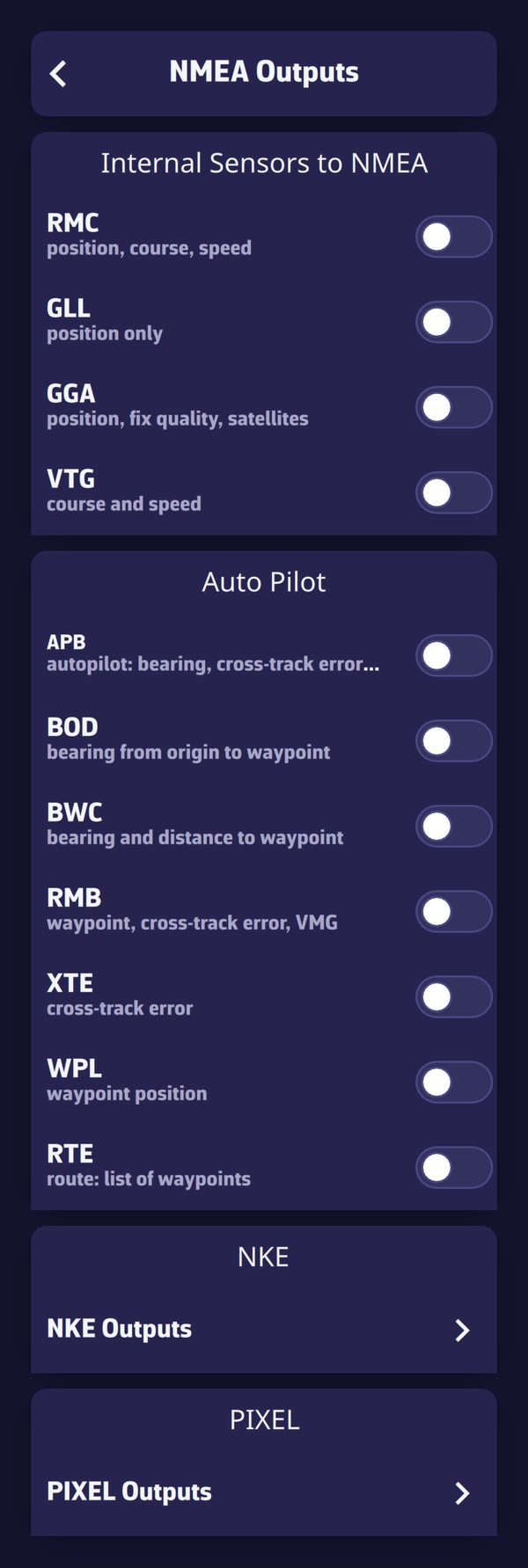 The NMEA Outputs page
NavimetriX can also send NMEA 0183 to the instruments: the device’s position for a plotter without GPS, navigation sentences for the autopilot, performance data for NKE or PIXEL displays. Outputs go out over the configured NMEA link: they therefore require the Premium subscription and an active link.
- Set up reception first (see NMEA 0183 connection).
- In “Settings”, “GPS & NMEA”, tap “NMEA Outputs”, at the bottom of the page.
- Turn on the sentences you want.
- Check the output in the “Incoming NMEA sentences” console: the sentences sent appear there in orange.
Going further
When and where outputs go
- Sentences are sent once per second, as soon as an NMEA link is active. They are spread across the second so as not to saturate slow gateways (such as the NKE Wi-Fi box).
- They go out over the instruments link. If there are no instruments (a boat with only a GPS and an AIS), they go out over the first active link.
- Waypoints and routes (WPL, RTE) preferably go out over the dedicated GPS link when it is active: a plotter often only accepts these transfers on its own link.
- Without a valid boat position, only the barometer pressure is sent, so as never to send false values to the autopilot. Nothing is sent either during a track replay or while following another boat.
Internal sensors to NMEA
The “Internal Sensors to NMEA” block sends the boat’s position (generally that of the device’s GPS) to the instruments:
| Sentence | Content |
|---|---|
| RMC | position, course, speed |
| GLL | position only |
| GGA | position, fix quality, satellites |
| VTG | course and speed |
| XDR / MDA | device barometer, pressure (only on a device that has a barometer) |
RMC and VTG carry undamped speed and course: the plotter or autopilot does its own damping. The pressure goes out every 5 seconds, corrected by the “Device sensor offset”. Only the device’s barometer is sent: an NMEA barometer is already on the network.
Autopilot
Warning: when these boxes are ticked and an autopilot receives these NMEA sentences, it changes the boat’s course. This is very convenient, but must be used with the greatest caution.
The “Auto Pilot” block sends the navigation sentences toward a waypoint. They only go out when a destination is active: a “Goto” to a POI or a route being followed (see Navigating to a POI and following a route).
| Sentence | Content |
|---|---|
| APB | autopilot: bearing, cross-track error, steering |
| BOD | bearing from origin to waypoint |
| BWC | bearing and distance to the waypoint |
| RMB | waypoint, cross-track error, VMG |
| XTE | cross-track error |
| WPL | waypoint position |
| RTE | route: list of waypoints |
The cross-track error (XTE) is the distance between the boat and the line joining the previous waypoint to the next. Waypoint names are sent in capitals and limited to 10 characters, without accents or commas: a name that is too long makes some instruments reject the whole sentence. Check your autopilot’s manual to see which sentences it expects; APB and RMB are the most common.
NKE outputs
“NKE Outputs” sends proprietary NKE sentences:
- “Gyrographic”, “Performance data”: the polar’s target speed, the target VMG angle and the speed efficiency;
- “Multigraphic”, “Dynamic data”: up to eight values, one per “Channel 1” to “Channel 8”, to show on a Multigraphic display.
For each channel: “–” (nothing), STW_TGT (target speed), STW_EFF (speed efficiency), VMG, VMG_TGT (target VMG), VMG_TGT_ANG (target VMG angle), VMG_EFF (VMG efficiency), BTW (bearing to waypoint), DTW (distance to waypoint), VMC (velocity made good to the waypoint), TTG (time to go), D2LL and T2LL (distance and time to the layline).
PIXEL outputs
“PIXEL Outputs” sends data to PIXEL EXOCET displays, over UDP to the display’s “IP address” (192.168.100.251 by default):
- “Performance”: polar speed and percentage achieved, polar VMG and percentage achieved, target VMG angle and speed;
- “Waypoint”: bearing, distance and time remaining to the active waypoint;
- “Current”: the current forecast at the boat’s position, taken from the displayed current GRIB, otherwise from the current atlases, multiplied by the percentage set beside it (80 to 150%, 100% by default).
Relay on local network
Three relays make data available to the other devices on board, without Internet, as a UDP broadcast on the local Wi-Fi network. The relay port is 10111 by default; it must not be a port that one of the device’s links listens on.
- “Relay device GPS on local network” (visible when “GPS source” is “Internal”): the phone sends its position. A computer without GPS listens to it as an NMEA link over UDP on this port (in advanced mode, as the dedicated GPS link).
- “Relay device barometer on local network” (“Barometer” block, on a device that has a barometer): the device’s pressure, for a computer or instruments without a barometer.
- “Relay on local network” (advanced mode, for a UDP, TCP or SERIAL link): what the link receives is re-sent for the other devices. A computer connected to the instruments by USB, or that takes up a gateway’s only TCP slot, can thus feed the whole boat. With UDP, the relay is for devices that only send their data to a single IP address, the device’s own: without it, the other devices on the network would not receive it. Demo data is never relayed.
Both devices must be on the same Wi-Fi network; some routers isolate their clients from one another. The app must stay open on the device that relays.
Sharing without a local network
To follow the boat from ashore, the remote cockpit goes through the Internet: see Remote cockpit.