Multiple links and position source
ExpertThe essentials
On many boats, the navigation instruments, the GPS and the AIS receiver are separate boxes, each with its own Wi-Fi or port. Advanced mode lets you listen to them all at the same time, without a multiplexer.
- In “Settings”, “GPS & NMEA”, turn on “Advanced mode” (at the bottom of the block).
- The page reorganizes into six tabs: “GPS”, “Instruments”, “AIS”, then “Extra 1”, “Extra 2”, “Extra 3”.
- Set each link in its tab: protocol, address, port. Or tap “Scan NMEA devices”: the scan suggests a role for each stream found.
- In the “GPS” tab, choose the “GPS source”, the link that provides the position.
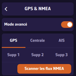 Advanced mode: six tabs and the scan
Going further
The six links
| Tab | Link title | Use |
|---|---|---|
| “GPS” | “GPS” | a dedicated GPS |
| “Instruments” | “Navigation instruments” | wind, depth, log, heading, and often the position |
| “AIS” | “AIS receiver” | a separate AIS receiver or transponder |
| “Extra 1” to “Extra 3” | “Additional link 1” to “3” | everything else: barometer, man overboard receiver, a stand-alone sensor |
- Each link has its own “NMEA Protocol”, address and port, or serial port and baud rate. An unused link is set to “None”.
- By default each link listens on a different port: 10110 for the instruments, 10111 for the GPS, 10112 for the AIS, then 10113 to 10115. Two links on the same port would not work (see the “Port already used by another input” message in NMEA 0183 connection).
- The “NMEA” switch in the “Instruments” tab controls all links: when it is off, nothing is received or sent.
- “DEMO” mode only exists for the instruments. During a demo, the other links stay silent, so that real data is not mixed with replayed data.
- With UDP, TCP and SERIAL, each link can relay what it receives on the local network (“Relay on local network”, “Relay port”, 10111 by default), for example so that a computer connected over TCP or USB feeds the tablets, or to relay a device that only sends its data over UDP to a single IP address. See NMEA outputs.
Measurements (wind, depth, log, heading, pressure…) are taken wherever they arrive. AIS targets from all links are merged: a vessel appears only once, whichever link received it.
Warning: going back to simple mode does not just hide the tabs, it switches off the GPS, AIS and additional links. Their settings are kept and come back when you turn advanced mode on again.
The position source
The position, on the other hand, can only come from one link at a time, otherwise the boat would jump from one point to another. In advanced mode, the “GPS source” in the “GPS” tab offers:
- “Internal”: the device’s GPS. On a Mac, the position deduced from Wi-Fi or the IP address is never used in Navigation mode;
- “Instruments”: the position arrives with the instruments, the most common case;
- “GPS”: the dedicated GPS link. Its settings only appear in the tab in this case;
- “AIS”: a transponder with its own built-in GPS.
The dedicated GPS link only works if “GPS source” is set to “GPS”: choosing another source stops it.
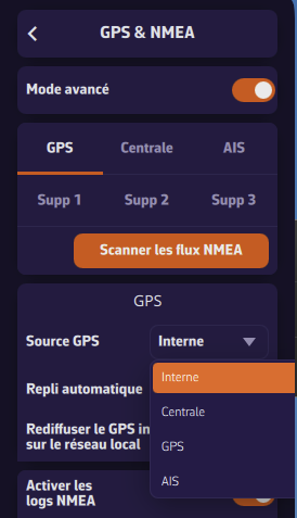 “GPS source” in advanced mode
Automatic fallback
| Setting | Default |
|---|---|
| “Automatic fallback” | on |
If the designated source stays silent too long, NavimetriX looks for another position rather than leaving you without one. A link is considered silent after three times its usual position sending interval, with a minimum of 10 seconds and a maximum of 2 minutes: a GPS sending one position per second is therefore declared lost after 10 seconds.
The fallback order is: the designated source, then the instruments, the AIS, the dedicated GPS (if it is the designated source), additional links 1 to 3, and finally the device’s GPS. Only a link that provides a real position can be chosen: an AIS receiver without GPS is never used.
A banner announces each switch (“Position: switched to … (… lost)”), then “Position: back on …” when the original source returns.
Disabling the fallback is only useful to see immediately that a GPS has dropped, even at the cost of losing the position. In simple mode, the fallback exists too: with “GPS source” on “NMEA”, the device’s GPS takes over if the instruments no longer provide a position.
The AIS source
In the “AIS” tab, the “AIS source” says whether a dedicated AIS receiver exists:
- “Instruments”: the AIS sentences arrive with the instruments, there is no dedicated AIS link (it is stopped);
- “Dedicated”: the “AIS receiver” link is set and listened to.
AIS targets require the Premium subscription. Their display is described in AIS targets.
Scanning in advanced mode
In advanced mode, the scan does not stop at the first stream: it looks for all of them, then suggests a role for each based on what it contains (AIS: “AIS”; only a position: “GPS”; instrument data: “Instruments”). A list to the right of each stream lets you change this role, choose “Link 1” to “Link 3”, or “Ignore”. A role can only hold one stream: assigning it to one removes it from the stream that had it.
“Apply settings” sets each link. If an instruments stream also contains the position or AIS, the “GPS source” or “AIS source” switches to “Instruments”, unless a dedicated GPS or AIS receiver was found.
Speed reference and true wind
Advanced mode adds a calculation block, “Speed reference” and “True wind”. It is described in Received data and calculations. Going back to simple mode resets these two settings to their default value.