Which sail to carry
ExpertThe essentials
A Sailchart is your boat’s sail chart: for each wind strength and angle, the sail to carry. It is part of the polar. If your polar includes one, NavimetriX knows at any moment which sail it prescribes for the measured wind, and two instruments display it.
- The short answer: add a “Numeric value” and choose the “Sail” data. The tile shows the sail code (J2, C0, S2…) on a badge of its color.
- The full answer: add the “Sailchart” instrument. It shows where you are on your Sailchart, with the track of the last few minutes.
- Both require the true wind from the instruments (NMEA connection) and a polar with a Sailchart.
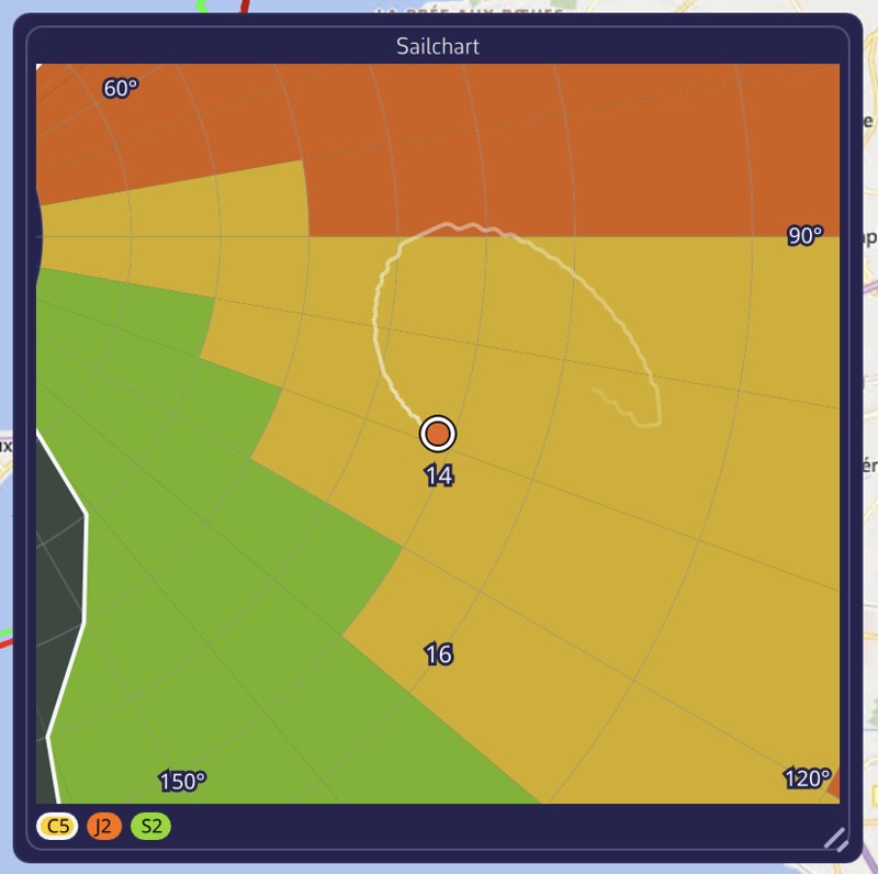 Sailchart instrument on the chart: the boat’s orange dot and its track of the last ten minutes on the sail chart, sail legend at the bottom with the sail in use circled
Going further
The “Sail” tile
It is one of the data choices of the “Numeric value”. Its title is “Sail”, or “SAIL” when tile titles are set to acronyms. The badge color is that of the sail in your Sailchart, the same as everywhere else in the app. The tile stays empty if the polar has no Sailchart; it has no sparkline, since it displays a name and not a number.
The same sail appears, segment by segment, in the “Sail” column of the Course tracking instrument.
The “Sailchart” instrument
It reproduces the Sailchart drawing: the radius represents the wind strength, the angle represents the wind angle, and the two tacks are drawn as a mirror image. The colored zones are those of the sails, an orange dot marks your position.
- The view is centered on the boat and zoomed in: seen whole, the Sailchart would shrink a two-knot shift to one pixel. Up close, you can see at once whether you are sailing in the middle of a zone or against a boundary.
- The track is what gives the tile its meaning: it tells you whether the wind is rising or falling, and whether you are approaching the moment to change sail. Since the angle is signed, a tack or a gybe reads as a jump from one side to the other.
- The legend at the bottom names the visible sails, from the largest zone to the smallest; the one you are carrying is highlighted.
Instrument settings (right-click or long-press):
| Setting | Values | Default |
|---|---|---|
| “Track” | “None”, “5 min”, “10 min”, “30 min” | 10 min |
| “Zoom” | “± 5 kt”, “± 10 kt”, “± 20 kt”, “All” | View zoomed on the boat |
| “Square tile background” | Yes / no | Yes: the instrument is created square, but can become round |
“Zoom” sets the band of wind strength shown on either side of your current wind; “All” shows the entire Sailchart. The track takes one point every 2 seconds; setting it to “None” erases the points already taken. These settings apply to all copies of the instrument on the device.
If the chosen polar has no Sailchart, the tile displays “This polar has no Sailchart”. It follows the polar in use: choosing another one or editing its Sailchart shows up immediately.
How the sail is determined
Two precautions, the same as for routing.
- The angle is brought back into the best-VMG cones. VMG is the speed of approach along the wind axis; both upwind and downwind, you do not sail closer or deeper than the polar’s best VMG angle. When you are closer to the wind than that angle, the app takes the optimal upwind angle, and downwind the optimal gybing angle. Pinching upwind, the Sailchart has nothing at 10° from the wind, whereas you are carrying the sail for your upwind angle perfectly well.
- The sail in place is kept as long as it suits. The app starts from the sail already recommended, which avoids flickering between two sails when you run along a boundary.
See also
- Polars and Sailchart, to create or import a Sailchart
- Course tracking
- Instrument types
- FAQ: How do I know which sail to carry right now?
- FAQ: What is a Sailchart and what is it for?