Course tracking
ExpertThe essentials
When you are following a route or heading to a POI, the “Course tracking” instrument answers the questions you ask yourself on board: is it still far? what heading should I steer? which sail? what time will we reach the next mark? It displays one row per remaining leg, from the boat to the last mark.
- Start navigating to a mark: “Goto” on a POI, or following a route (see POIs, routes and ZOIs).
- Add the instrument: “+” button, “Add instrument”, “Course tracking”, then “Add to instrument bar” or “Add to chart”.
- Widen the tile to see more columns: the handle in the lower right corner in the bar, the corner handle or the pinch on the chart.
- Choose the wind used in the instrument’s settings (right-click or long-press), “Wind source” setting.
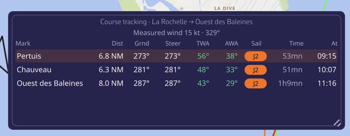 The Course tracking instrument, all columns displayed
The tile’s title shows the name of the route being followed, and the next line the wind used for the calculation (for example “10 min mean wind: 10 kt · 57°”).
Going further
The columns
The tile displays as many columns as its width allows. Narrow, it keeps the essentials; widened, it adds the rest.
| Column | Content | Visible |
|---|---|---|
| “From” | The leg’s starting mark (“Boat” for the first) | Widest tile |
| “Mark” | The target mark | Always |
| “Side” | The side on which to leave the mark, if specified in the route | Wide tile, and at least one mark with a side |
| “Dist” | The leg’s distance | Always |
| “Grnd” | The course over ground, the actual direction of travel | Wide tile |
| “Steer” | The heading to hold at the helm, corrected for current | Always |
| “TWA” | The true wind angle expected on the leg | Always |
| “AWA” | The apparent wind angle expected | Medium or wide tile |
| “Sail” | The sail recommended by the Sailchart of your polar | Always |
| “Time” | The planned time for the leg | Medium or wide tile |
| “At” | The arrival time at the mark, followed by “D+1”, “D+2”… if it falls on another day | Always |
In the “Side” column, a solid arrow indicates a mark to round, a hollow arrow a simple side constraint.
On a narrow tile, each leg becomes a small two-line card rather than a table with truncated cells. The “Text size” setting (“Small”, “Normal”, “Large”, “Extra large”) enlarges the whole tile.
Where the wind comes from
The “Wind source” setting offers four choices:
- “Measured” (default): the wind from your instruments. If they give nothing, the instrument takes the forecast from the GRIB, the weather forecast file loaded in the app;
- “Avg 10 min”: the average of the measured wind over the last ten minutes, more stable for choosing a sail or a heading. While the history is too short, the instantaneous wind is used instead;
- “Forecast”: the GRIB wind only. This choice is grayed out if no GRIB covers your position at the current time;
- “Forced”: a strength (0 to 70 knots) and a direction that you impose, to see what a wind shift would do. Both values start from the current wind.
With “Measured” and “Avg 10 min” (when the instruments give a wind) as with “Forced”, the same wind is used for all legs. With “Forecast”, each leg is calculated with the wind forecast at the middle of the leg, at the time the boat is due to enter it: a long course is not evaluated with the wind at the start.
These settings apply to all copies of the instrument on the device.
How the calculation is done
For each leg, the instrument:
- reads the selected wind and the GRIB current at the middle of the leg, at the planned entry time. The current always comes from the GRIB, as no instrument measures it ahead of the bow;
- looks up in the polar the boat speed at that wind angle and strength;
- corrects the heading for the current so that the course over ground stays on the mark; this is the “Steer” column;
- deduces the apparent wind, the duration and the time of passage, then moves on to the next leg from that time;
- chooses the Sailchart sail for that angle and strength, keeping the previous leg’s sail as long as it suits, so as not to change sail for nothing.
Durations are therefore those of the polar, not those of your current speed. The instrument recalculates every 30 seconds, and immediately when the route or the target mark changes.
Possible messages
- “No route being sailed”: neither a route being followed, nor a POI targeted by “Goto”.
- “Course completed”: the last mark has been passed.
- “No GRIB forecast here: distances and courses only” or “No wind here: distances and courses only”: without wind, the tile keeps the geometry of the legs (distance, course) but cannot calculate sail or time.
- “Waiting for the polar…”: just after startup, while the polar is loading.
See also
- Which sail to carry
- Instrument bar and instruments on the chart
- POIs, routes and ZOIs, to create a route and specify the side of marks
- Weather: GRIB files and forecasts
- FAQ: How do I follow my course leg by leg?
- FAQ: How do I record which side to leave a mark?