If your polar carries a Sailchart, the app knows at all times which sail it prescribes for the wind you have. Two instruments show it.
The short answer: the Sail tile
Add a Numeric value instrument and pick the Sail data. It shows the sail's code — J2, S2, C0… — on a chip in its own colour, the same one used everywhere else in the app.
The full answer: the Sailchart tile
This instrument shows where you are on your own Sailchart. It is the counterpart of the polar performance tile, applied to sails: the radius is wind speed, both tacks are mirrored, and an orange dot marks your position.
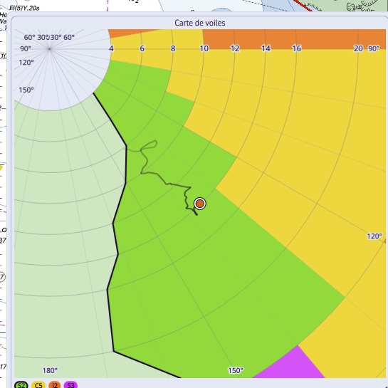
The view is zoomed around the boat, which stays at the centre. Seen whole, a two-knot shift would be a single pixel; from close up you see at once whether you are in the middle of a region or hard against a boundary.
The trail
This is what makes the tile worth having. Set in the instrument settings — None, 5, 10 or 30 minutes — it tells you whether the wind is building or dying, and whether a sail change is coming. The angle is signed, so a tack or a gybe reads as a jump from one side to the other.
The Zoom setting picks the wind band shown around you: ± 5, ± 10, ± 20 knots, or the whole Sailchart. The legend at the bottom names the visible sails, the one you carry being ringed.
How the sail is determined
Two precautions, the same the router takes. The angle is first folded into the best-VMG cones: hard on the wind the Sailchart holds nothing at 10°, although you are indeed carrying the sail of your beating angle. Then the current sail is fed back into the lookup, which stops the display flickering between two sails when you sail along a boundary.