Geogarage is an aggregator of official marine charts that brings together the charts of over 30 national hydrographic offices. NavimetriX displays the entire Geogarage catalog as raster charts (images cut into tiles). You take out the subscriptions of your choice on the Geogarage website, then sign in to your Geogarage account in NavimetriX to use the official charts on all your devices.
Important: one subscription = a full service, not a region
Unlike charts sold by geographic region, such as C-MAP charts (which NavimetriX also supports, in beta: see C-MAP charts in NavimetriX), a Geogarage subscription gives you access to every chart published by a hydrographic office, wherever in the world that office publishes. You pick your subscriptions based on which offices cover your sailing areas, not the other way around.
A few examples:
- SHOM (France): all French charts, mainland and overseas territories (French Antilles, French Polynesia, Réunion, Mayotte, French Guiana, New Caledonia, Saint-Pierre-et-Miquelon, French Southern Territories…). With a single SHOM subscription you get detailed coverage wherever France has dependencies, and global ocean passage charts too.
- NOAA (United States): every chart of US waters: East Coast, West Coast, Gulf of Mexico, Alaska, Hawaii, Puerto Rico, Pacific territories.
- BSH (Germany): all German charts of the North Sea and Baltic.
- UKHO (United Kingdom): all British Admiralty charts covering the United Kingdom and its dependencies (former Commonwealth territories, South Africa, Malta, NGA), and global ocean passage charts too.
For instance: if you sail along the French Atlantic coast and in the French Antilles, a single SHOM subscription covers both areas, with no separate coverage to buy for each archipelago. For a long voyage crossing multiple jurisdictions, you combine the subscriptions you need (e.g. SHOM + NOAA to reach the Caribbean from France via the US East Coast).
Hydrographic offices included in the catalog
The Geogarage catalog covers the world's main sailing areas with official charts from:
- Europe: SHOM (France), UKHO (United Kingdom), BSH (Germany), Kystverket (Norway), Sjöfartsverket (Sweden), Geomatikk (Finland), Belgian Hydrographic Service, Danish Geodata Agency, Rijkswaterstaat (Netherlands), Instituto Hidrográfico (Portugal), Instituto Hidrográfico de la Marina (Spain), Croatian Hydrographic Institute, Maltese Maritime Authority…
- Americas: NOAA (United States), Canadian Hydrographic Service, DHN (Brazil), SHN (Argentina), SHOA (Chile), Instituto de Hidrografía (Cuba)…
- Asia and Pacific: JHD (Japan), KHOA (Korea), Maritime New Zealand, Australian Hydrographic Office, Philippine NAMRIA, Taiwan Hydrographic Bureau…
- Africa and Middle East: South African Navy Hydrographic Office, Mozambique, Israel, Oman, regional Persian Gulf services…
Browse the interactive catalog
Select a hydrographic service below to view the exact chart coverage included in its annual subscription:
Annual subscription pricing
Prices vary depending on the hydrographic service and the geographic area covered. You can subscribe to one or several services on the Geogarage website: NavimetriX does not sell these subscriptions. Subscriptions are tied to your Geogarage account and usable in NavimetriX on your Android, iOS, macOS, Windows and Linux devices.
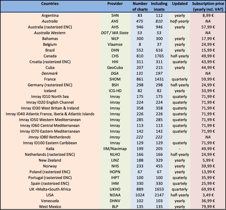
For up-to-date pricing and details, see the Geogarage website.