What's new in version 1.23
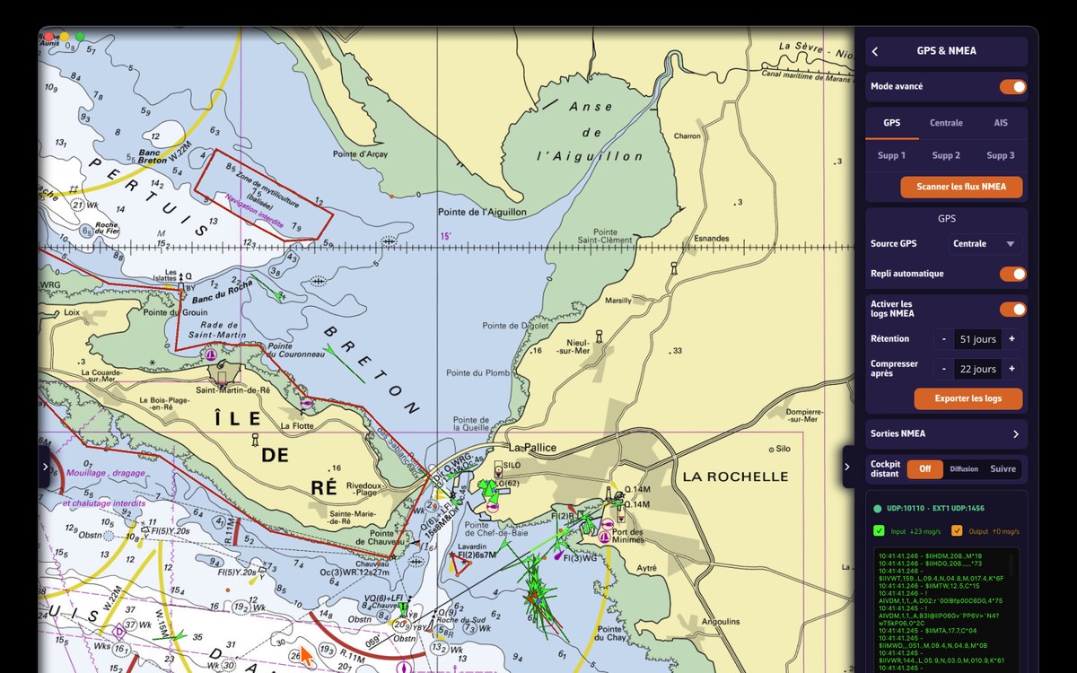
Version 1.23 lifts a limit many of you reported: until now, NavimetriX listened to a single NMEA link. On a boat where the instruments, the GPS and the AIS are three separate boxes, you needed a multiplexer. Not any more.
Six links instead of one
Open Settings › GPS & NMEA and turn on Advanced mode: the page reorganises into six tabs, and your existing link becomes the one on the Instruments tab.
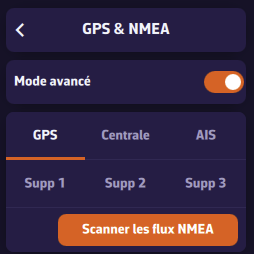
- GPS: a dedicated GPS, when the position does not come from the instruments.
- Instruments: wind, depth, log, heading, and often the position.
- AIS: a separate AIS receiver or transponder.
- Extra 1 to 3: everything else, a barometer, a man-overboard receiver, an isolated sensor.
Each tab carries its own link, with its own protocol, address and port. A link you do not use is declared by setting its NMEA protocol to None, which is clearer than a switch turned off next to a filled-in address.
AIS targets from every link are merged into a single list: no matter which way a vessel arrives, it appears only once. Wind, depth and the other readings are taken wherever they arrive.
When in doubt, leave advanced mode off: if a single box emits everything, still by far the most common case, the standard page is enough and nothing changes for you.
The scanner finds your devices on its own
If you know neither the address nor the port of your gateway, let NavimetriX look. Scan NMEA streams listens on all the usual ports at once and knows the settings of some twenty gateways on the market.
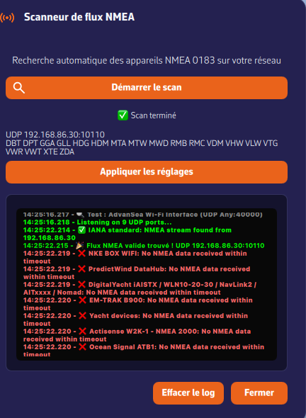
The stream found is shown with its address, its port and the sentence families it carries: MWV for wind, DBT for depth, VDM for AIS. Three letters are enough to recognise your box at a glance. Apply settings fills in everything.
In advanced mode the search goes further: it also tries TCP links and serial ports, and returns the list of every stream on board. Each line gets a menu stating what that stream is for, with a suggestion already made based on its content.
The position comes from one link only
This is the most important setting on the page. Wind or depth can arrive from anywhere without any risk of confusion; the position, however, can only come from one source, otherwise the boat would jump from one point to another.
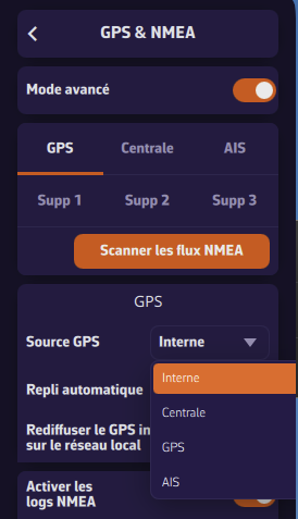
GPS source offers four choices: Internal for the device’s own GPS, Instruments when the position arrives mixed in with the instruments, GPS for a dedicated GPS, and AIS for a transponder carrying its own.
Automatic fallback
On by default, and best left that way. If the designated source goes quiet for more than about ten seconds, NavimetriX looks elsewhere rather than leaving you without a position: it tries the instruments, then the AIS, then the device’s GPS. A banner tells you what it switched to, another tells you when the original source is back.
Fallback only accepts a link that provides a real position. An AIS receiver without a GPS, emitting only targets and a clock, will never be chosen: it would freeze the boat instead of moving it.
For the full story, see the FAQ: Which link provides the position, and what if it fails?
Sharing a phone’s GPS with a computer
This is the most requested use case: a phone on board, a computer without a GPS, and the wish for the second to follow the first. Nothing to install.
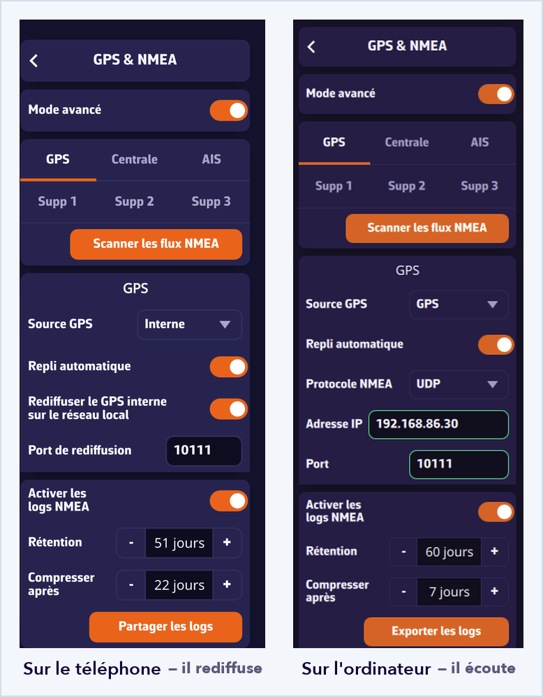
- On the phone, advanced mode, GPS tab: GPS source on Internal, then turn on Rebroadcast internal GPS on the local network. Note the port offered.
- On the computer, advanced mode, GPS tab: UDP protocol and that same port, then GPS source on GPS.
The computer then follows the phone’s position while taking its instruments from elsewhere. If the phone shuts down or leaves the network, automatic fallback takes over.
The same mechanism works the other way round: on a TCP or serial link, the Rebroadcast on the local network switch re-emits every sentence over UDP to the whole network. A computer cabled to the instruments can thus feed the tablets on board, and replace a multiplexer.
For the full story, see the FAQ: Can I share my phone’s GPS with a computer that has none?
An improved anchor alarm
- The radius can be changed with the alarm armed. The zone stays frozen by default, but “Edit radius” in the anchor menu brings the handle back for one adjustment, without disarming: the rode can be veered in the middle of the night without lifting the watch.
- The banner gives the distance and bearing of the anchor, plus the bearing from the bow, red to port and green to starboard. It can be dragged anywhere on the chart.
- The anchor is protected: it is only draggable after going through “Move anchor”. With the alarm armed, that entry disappears.
For the full story, see the FAQ: How to use the anchor drag alarm?
Routing: tacks and gusts
- Tack and gybe penalties are now set in seconds, which can be measured directly on board instead of guessed.
- The gusts used by the routing match the weather file: the calculation and the file now say the same thing.
Instruments
- The instrument bar can be hidden, giving the whole screen back to the chart.
- Confirmation before deleting an instrument, so a careless gesture no longer costs you a layout.
- Wind averaging is adjustable: smooth it more in a rough sea, or keep the raw reading when beating.
And also
- True full screen on Android, without the system bars.
- Various fixes and stability improvements.
Going further
NMEA is the part of NavimetriX that raises the most questions. Four new FAQ entries therefore accompany this version:
- My instruments, GPS and AIS are on separate links. Can I connect them all?
- Which link provides the position, and what if it fails?
- Can I share my phone’s GPS with a computer that has none?
- NavimetriX shows “Port already used”. What should I do?
Fair winds, and enjoy 1.23!