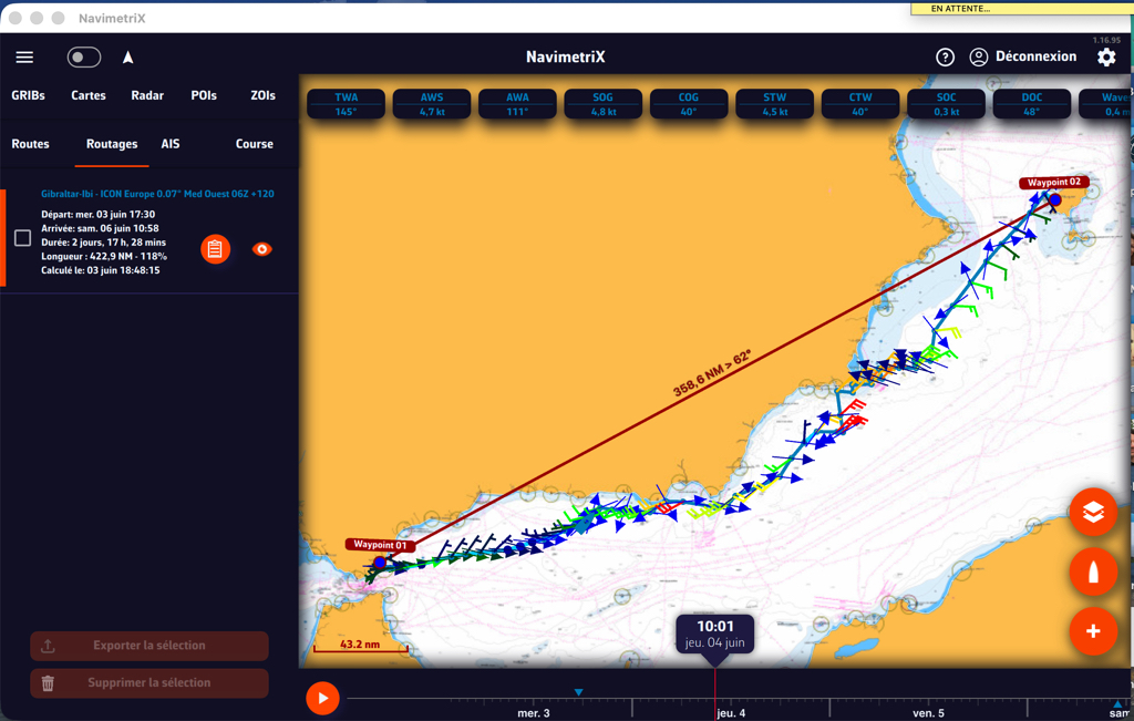
Blog

Blog
· Francis

How to Perform Effective Routing

Basic Principle

Routing is a navigation aid that can serve two different — but not necessarily contradictory — purposes:

  • On passage: comfort and safety, avoiding sea and wind conditions that the boat and crew cannot handle,
  • Racing: performance, the best efficiency for the best passage time.

Routing is like a cooking recipe: you first need good ingredients:

  • A speed polar containing the theoretical target speeds the boat can achieve based on true wind speed (TWS) and the sailing angle relative to that wind direction (TWA).
  • A route with a minimum of waypoints: preferably only departure and destination. Intermediate waypoints should only be used for mandatory passage points.
  • Several GRIB files broadly covering the route: wind, waves, currents — the most recent available, with a time horizon sufficient for the approximate duration of the passage.
  • A departure date within the temporal coverage of the GRIB files and as early as possible.

The Recipe

The recipe is based on a routing algorithm — a clever calculation whose inner workings are classified top secret. This calculation determines an optimised route by combining wind values and directions, currents and waves with the boat’s speed polar values, along a course from departure to destination.

Read more →
Blog
· Francis

VMG, VMC, XTE, TAE: a few explanations

Acronyms are used to concisely specify navigation data. This language was originally developed for marine electronic instruments, GPS units and chart plotters. It is now found in digital navigation applications.

These acronyms, in the form of three capital letters, are the initials of English terms defining navigation-specific data and related functions. They make it easy to display information on screens while taking up very little space. Among them, some can be confusing.

Read more →
Blog
· Francis

Analysis charts to better understand GRIBs

Sailing is about anticipating. When it comes to weather, anticipating means looking far ahead and well in advance, even for short coastal passages. Tracking weather systems coming from the west over the North Atlantic, for instance, helps plan a good weather window for next weekend’s sail. This applies to all parts of the world.

A pedagogical tool

The ability to overlay meteorological analysis charts on GRIB files provides a better understanding of weather phenomena and their evolution. The display of fronts complements the colourised data representation — such as wind strength — and the point symbols like vectors and barbs in GRIB files.

Read more →